
Hull Geological Society
Yorkshire Chalk Walk
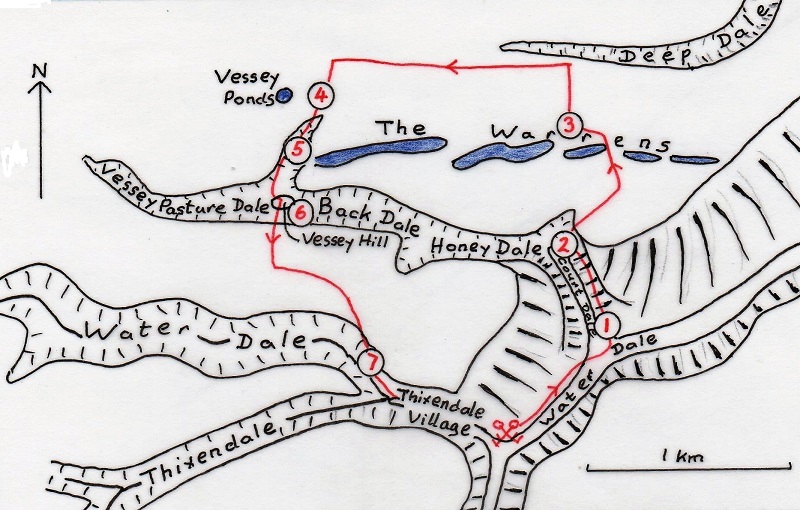
A geomorphological walk from Thixendale
Start from the
Cross Keys pub in Thixendale and take the field path NE along Water Dale,
crossing the entrance to Court Dale and climb up to a small coppice.
From here the view shows some
typical features of dry valleys. The slopes of Water Dale are markedly
asymmetric, the NW-facing slope being much the steeper. There is no simple
explanation for this. It is not due to differences in rock type as everything is
chalk and it does not appear to be related to aspect since other dry valleys
parallel to Water Dale
have symmetrical sides. There is an abrupt
change in slope onto the flat floor of the valley which here lies at about 120m
OD and close to the base of the Chalk. The underlying Kimmeridge Clay would
explain the presence of standing water on the valley floor after wet weather,
and, of course the name of the valley.
The melting snows of early summer would have produced a
lot of surface water which was unable to drain through the frozen subsoil. The
flat floor of the valley would have been occupied by a stream of braided
channels flowing through drifts of chalk rubble.
Honey
Dale divides and the larger fork, Back Dale, narrows and appears partly blocked
by rounded protuberances of its southern slope. The reason for this will become
more apparent later in the walk.
Something of the
This
patch of wet ground is known as “Vessey ponds”. Large quantities of flint
artefacts have been found around the ponds and it is thought that in
pre-historic times they provided a water supply on the otherwise dry
Here
there is a prominent chalk scree, to what extent man-made is uncertain. It gives
a good illustration of the nature of the
This small isolated hill is a good example of a deep
rotational land slip. The steep slope to the S has failed and a slice has
slipped down onto the valley floor partly blocking it. Looking to the E along
Back Dale similar slips can be seen. The eastern end of these were viewed from
Stop 2 earlier in the walk. Such landslips would have been very active under
permafrost conditions during the last glaciation.
From Vessey Hill a steep
climb S brings you back onto the
Notice the contrast in the form
of the two dry valleys to the W.
Water Dale has a sinuous course with
interlocking spurs but Thixendale is quite straight. I offer no explanation but
these differences certainly add to the beauty and diversity of
the
Copyright - Hull Geological Society 2017
Registered Educational Charity No. 229147