
The Yorkshire Chalk
Previous Studies.
Research by members of the Hull Geological Society.
Working on the geology of the chalk is not easy - it is all white and not as instantly rewarding as other strata. Members of the Hull Geological Society have had an interest in the topic since its earliest years.
G W Lamplugh lived at Bridlington and studied the local rocks. He is perhaps most famous for his work on the Speeton clay, but he did measure the coastal sections of the Chalk and published their stratigraphy in 1895. He went on to become a professional geologist, eventually becoming the Director of the geological Survey and a fellow of the Royal Society.
D W Toyne started to carry out fieldwork on the inland exposures, but was killed in a motor cycle accident in 1935. His collection and notebook were given to the young Ted and Willy Wright. Tom Sheppard, Curator of Hull Museums, encouraged their interest in the Chalk. One of their first important finds was a starfish at Dane's Dyke. Robert Stainforth told me that it was actually found by their mother when having a picnic, apparently she thought it looked like a set of false teeth. They published a paper about a large variety of fossils found under a large ammonite at Kiplingcotes Station Quarry. Ted and Willy continued Toyne's work and concerned that they may not survive the war published an incomplete report in 1942. After the war Willy worked in London and continued his amateur research into chalk fossils, publishing memoirs on ammonites and echinoids. Ted returned to Hull and worked (I think) for Reckitt and Coleman and became an (amateur) expert on marine archaeology. They did not continue their studies of the Yorkshire Chalk. They both received honorary degrees from the University of Hull in 1987.
The Hull Museums geological collections were destroyed by incendiary bomb in 1943. Including the large collection of chalk fossils purchased from the Mortimer Museum in Driffield. By 1970 members of the Society were concerned about the lack of geology in the Museum and Percy Gravett reprinted copies of the Wright brothers' 1942 paper to start a project to create a new collection of Chalk fossils.
Felix Whitham, the Treasurer of the Hull Geological Society, had a long interest in the Chalk and in 1984 proposed the stratigraphy of the Yorkshire Chalk and the creation of a collection of Chalk Fossils as the topic for the Society's Centenary Project. A group including Lynden Emery, Donald Beveridge, Tony Gear, Dave Finer, Mavis May, Felix Whitham and Mike Horne started to visit quarries and coastal exposures, logging the beds and collecting fossils. The plan was to give the fossils to the University of Hull Geology Department, but its closure was announced in 1988, the Centenary year! In response to a request for help in the Geologists' Association Circular Professor Malcolm Hart suggested that the Society collected samples for the microfossils; these were also used for geochemistry.
A poster of the stratigraphy of Melton Bottoms Chalk pit was displayed at a meeting of the Assoiation of Teachers of Geology in Cottingham in 1987 and the complete stratigraphy of the Yorkshire Chalk was prepared in time for the Sociaty's Centenary Meeting in June 1988. Specimens from the collection were also exhibited at the Centenary Meeting and Felix published the lithostratigraphy and biostratigraphy in 1991 and 1993 in the Proceedings of the Yorkshire Geological Society. He received an honorary degree from the University of Hull for this work in 1992.
Biostratigraphy.
Most of the early studies of the Chalk of the Northern
Province concentrated on the biostratigraphy.
Early works by Young and Bird and J Phillips in the
1820s carried very little detail. There were several detailed publications in
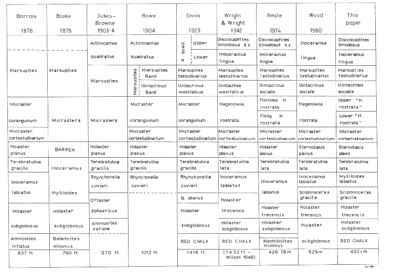
the 1870s. Barrois (1876, quoted in Blake 1878) made a brief visit to the area
and divided the Chalk into 8 biozones. Blake (1878) proposed
six biozones. There were other papers published in subsequent years
giving details of exposures and comment on the Chalk by the Rev. E Maule Cole,
the Mortimer brothers and G W Lamplugh.
In the early 1900s, Jukes Brown published memoirs for
the Geological Survey and Rowe (1904) added the description of the Yorkshire
coastal exposures to a series of papers for the Geologists' Association.
In 1929 Ennis published a short paper
on the zonation of the Yorkshire Chalk, turning Rowe's Uintacrinus Band into a
zone. In the 1930's D W Toyne started a project to visit all the inland
exposures, and assign them to biozones. Unfortunately his early death meant that
he did not complete the project (Horne 1989), but his field notebook was passed
to the young Ted and Willy Wright, who continued the work until the start of the
Second World War. They published the incomplete results in 1942, fearing that
they might not survive the War. In this they adopted Rowe's suggestion of using
Hagenowia rostrata as a local zonal fossil, and proposing a subzone of
Discoscaphites binodus for the highest beds. They did not take the local
research any further after the War.
Wilson's zonation in 1948 follows most of these changes. Neale 1974 split the Hagenowia rostrata zone into a flinty and flinty part, in the same way as Rowe split his Micraster cor-anguinum zone. Chris Wood, after working on the Hull and Brigg maps, introduced a further zone of Sciponiceras gracile in the 1980 B.G.S. Regional Guide.
This zonation, was broadly
followed the HGS Centenary Chalk Project, for
convenience; though with the knowledge that the whole biozonation is not
scientifically defined. All of the biozones in common use are actually
assemblage biozones and none are defined by a bioevent at the base. It is not
clear how authors have decided when where they should mark the base of the
zones, but they do manage to measure them nonetheless. The 'rostrata' biozone is
still named after a fossil that has been wrongly identified, and is only common
in part of the zone. This zone is also commonly divided into two parts on a
lithological basis, which is probably diachronous! The first fine scale
biostratigraphy by Whitham (1991 & 1993), uses the base of one zone at the first
flood of the 'zone fossil' not the first appearance and for another where two
'zone fossils' overlap takes the last appearance of the older one rather than
the first appearance of the younger one as the base.
The biozonation using macrofossils is in great need of
revision, using local zonal index fossils, to replace forms, which are common in
the Southern Province and bioevents to clearly define the bases of the zones.
Lithostratigraphy
Traditionally the Chalk in the Northern Province has
been divided into three units, derived from the divisions of the chalk of the
Southern Province: the Lower (or Grey) Chalk, Middle Chalk and Upper Chalk (e.g.
Jukes Brown 1903 4). This is why Rowe did not include the Cenomanian Chalk in
his 1904 paper about the White Chalk.
G W Lamplugh published measured sections of the
coastal exposures around Flamborough Head, in 1895. Although these tended to
group beds together, they fit well with the easurements of
the HGS Centenary Project. This was good lithostratigraphy and if his
work had been continued many of the problems with the Yorkshire Chalk would have
been solved years ago.
But Rowe placed such importance in his publications on
the use of fossils to study the Chalk, that no lithostratigraphy was done for
over 60 years (Gale & Cleevley 1989). Toyne (MS notebook) and the Wright
brothers (1942) followed Rowe's lead and only recorded the fossils to be found
in the inland quarries they visited. Many of these were found loose, and Willy
Wright saw no need to record the horizons from which they came (verbal comm.).
Most of the pits they visited have now been filled in.
Chris Wood mapped the Chalk of the area for the
British Geological Survey in the 1970's, leading to the publication of the Hull
and Brigg sheets, and the memoir (Gaunt, Fletcher & Wood 1992).
His work was the first study of the lithostratigraphy,
with bed by bed measuring and logging since Lamplugh. He divided the Chalk into
four Formations: the Ferriby Chalk Formation, the Welton Chalk Formation,
Burnham Chalk Formation and the Flamborough Chalk Formation. He also started a
new trend in the study of the Northern Province Chalk by naming important flint
and marl bands (Wood and Smith 1978, Gaunt, Fletcher & Wood 1992).
Much of Wood's work is based on the exposures in
Lincolnshire, and there were gaps in the Burnham Formation to be filled in and
no detail for the Flamborough Formation was given (Wood & Smith 1978).
Felix Whitham, an amateur geologist and Treasurer of
the Hull Geological Society, had also realised the importance of measuring
exposures and bed by bed collecting of fossils. He had started visiting quarries
in East Yorkshire and published some of the results as field handouts for field
meetings and as short papers in
Humberside Geologist. This work continued as part of the Hull Geological
Society Centenary Chalk Project and led to the publication of two papers on the
stratigraphy (Whitham 1991 & 1993). These named further marker horizons,
indicated observed macro fossil ranges and gave the first detailed description
of the Flamborough Formation, since Lamplugh's work nearly one
hundred years earlier.
Thickness of the Chalk.
From the times of early research, geologists have been
trying to give a thickness for the Yorkshire Chalk:
Barrois 1876
637 ft.[ca. 193m]
Blake 1878
790 ft.[240m]
Jukes Brown 1903-4
1270 ft.[385m]
Rowe 1904
1013 ft.[307m] ('White Chalk' only)
Ennis 1929
1416 ft.[429m]
Wilson 1948
1432 ft.[434m]
Neale 1974
426.78m
Wood 1980
529m
HGS Centenary
over 430m
The earlier figures were based on estimates or
measurements of the bio zones, with all problems involved due to lack of
scientific definition of the base of the zones. Neale's amazingly precise figure
to the nearest centimetre is probably the metrication of previous authors'
measurements.
Wood based his figure on the lithostratigraphy, but
realised that there was a lack of exposure in the Burnham Formation, and
probably included borehole information from Holderness, as the youngest beds are
not exposed.
The figure used here is based on the coastal exposures
of the Flamborough Formation and inland exposures of younger beds. There is
still a gap in exposure at the top of the Burnham Formation and between the
cliff exposure at Sewerby and the higher beds of the Discoscaphites biozone.
It is possible that the inland exposures represent a
thinner sequence than the coastal exposures, due to the effects of the Market
Weighton Structure.
The real answer to the question "How thick is the
Yorkshire Chalk?" is "It depends on where you measure it!" There is regional
variation in the thickness of the beds and the erosion of the top of the Chalk
is different for each outcrop or subcrop€. Without borehole information one has
to piece together a
composite log based on the correlation
of different exposures, and accuracy of these measurements will depend on the
criteria used when recording individual beds.
copyright Mike Horne 1985, 2000 & 2019
Copyright - Hull Geological Society 2019
Registered Educational Charity No. 229147