
Humberside Geologist No. 14
Humberside Geologist No. 14
The coastal exposures of Boulder Clay and erratics in Holderness.
By Stuart Jones
Over the past 130 years or so there have been many attempts to analyse and understand the Holderness Clays and Quaternary deposits. Quite understandably the coastal exposures by virtue of their accessibility have had much of this attention lavished on them.
This new work is an attempt to compare what is currently visible at various locations, to that which was observed in the past at these same locations by people such as G W Lamplugh, A Harker, J W Stather etc.
I have in my observations of the offshore rock fields and other deposits been able to avail myself of the benefits of certain modern day devices, which my predecessors had no recourse to, namely echo sounding equipment and sonar devices. These have enabled me, in the time I was engaged in fishing operations on this part of the coast, to map out some of the underwater obstructions and rock outcrops. Also GPS is now an invaluable aid so that it is possible to make an observation and then return years later to the exact point of observation, irrespective of physical changes to the surrounding topography that can sometimes confuse the unwary observer.
Well over a century has now passed since Clement Reid’s "Geology of Holderness" was published in 1885, in which he recognised four distinct different types of boulder clays, namely Hessle Clay, Upper Purple Clay, Lower Purple Clay and Basement Clay, as did Messrs Wood and Rome who preceded him by some seventeen years. Since then there have been many attempts to unravel the geology of the coastal area between Sewerby and Spurn.
The following text and illustrations constitute an attempt to re-visit some of the previous observations made in the past and to take note of the fossil fauna contained within the deposits, and to try to arrive at some conclusions as to their condition and also the reason for their presence at certain locations and their absence at other sites.
The coast of Holderness is one of the most productive locations for those wishing to collect and study fossils. The fossils in this location have one peculiarity, all being what geologists term "erratics".
This is to say that they are not where they should be, and yet they are where they are and where they have been for thousands of years since the last period of glaciation. There are also mysteries to be solved, for instance, why is one type of fossil to be found in one area and yet walk a mile along the same length of beach and no trace of that fossil will be seen, yet others will be there in abundance? The same applies to the rocks found in the boulder clay of the cliffs. The clay itself is made up of different colours and textures, some layers containing stones and pebbles and yet the layer next to it being smooth in texture with no stones whatsoever.
In the following pages we shall journey from the Chalk cliffs of Sewerby, south along the coast and eventually reach our journey’s end at Spurn Point, where the Humber estuary meets the North Sea. Along the way we will examine places and things of interest to both the casual observer and the trained geologist.
The boulder clays are present from Sewerby, which is just to the north of Bridlington. They are not very well exposed here due to the sea defence works and where these works end, to the north of the resort’s sea front, the rampant vegetation almost completely obscures any views of the lower portion of the cliff. One notable exception is an occasional exposure of sections of the Ipswichian Buried Cliff and the associated deposits. (Plates 1 & 2)
Plate 1
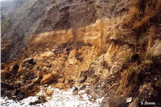
Sewerby Ipswichian Buried Cliff (viewed from the north east)
Plate 2
Sewerby Ipswichian Buried Cliff (viewed from the south east)
(Note remains of Pillbox from base of cliff)
The cliffs to the south of Bridlington are similarly obscured by sand dunes, vegetation and beach deposits, thus not affording any opportunities to the observer until a point south of Fraisthorpe is reached.
From Fraisthorpe, travelling southward, the boulder clay and other deposits of which the cliffs are formed are more readily visible, and due to the eroding action of the sea are constantly yielding up a supply of erratics. These erratics include fossils of many types such as ammonites, bivalves, belemnites etc. There are also a great many varieties of rocks ranging in size from small pebbles up to large boulders, many of which have the characteristic flattening and grooving of one or more faces, which indicates glacial action at some time in the past.
These rocks can help us to identify the origin of the source of the particular section of the clay or deposits in which they occur.
It is virtually impossible to perform any accurate stratigraphy other than to carefully note and record any particularly interesting exposures at the time they are observed. This is essential because they have a tendency to disappear in a very short space of time due to erosion. In some cases the exposures are eroded in as little as a few days or weeks at the most, depending on tides and storms. The most damaging storms are those from off the sea (Northeast to Southeast); Northwest to Southwest storms (off the land) have little or no effect.
The rate of erosion can be averaged at about 1.2 to 1.8 metres per annum, but it should be noted that this is only an average, and in some circumstances erosion can greatly exceed this.
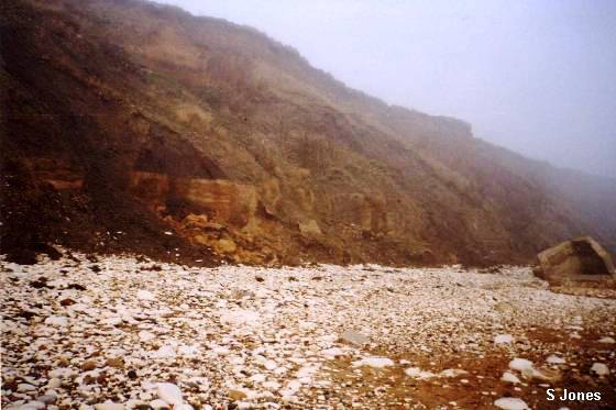
This ongoing erosion serves to provide a plentiful supply of rock specimens and fossils, some washed out of the cliff by direct action of the waves while others are exposed by large sections of the cliff being undercut by the sea, falling onto the beach and being broken up by wave turbulence. (Plates 3 & 4)
Plate 3
Cowden Beach after a storm (looking south towards Aldborough)
Plate 4
Mappleton Beach (looking north towards Hornsea)
It is a peculiarity of the Holderness coast that some areas or sections have a tendency to yield more specimens of certain types of fossil or fossils than do others. An example of this is an area to the north of Cowden where the clay on the beach has provided many good specimens of the large Belemnite Acroteuthis. Also, just to the south of Aldborough is an area of clay closely resembling Speeton Clay. (Plate 5)
Plate 5
Exposure of Speeton type pale clay (to the south of Aldborough)
This exposure has been the site of discoveries of specimens such as Rotularia (R.), phillipsii (Roemer) which is normally to be found in the B Beds at Speeton, the uncoiled ammonite Aegocrioceras quadratum (Crick) - C Beds and the bivalve Panopea neocomiensis (Leymerie) – B, C and D beds. Also to be found in the B beds at Speeton is the belemnite Oxyteuthis brunsvicensis (Strombeck).
Yet other areas are almost devoid of some types of fossils, for example, belemnites of any species are very few and far between at Easington.
All this gives rise to the theory that most of the fossils to be found on the Holderness coast have not travelled far along the coast by tidal drift. The fossils tend to stay where they have been in the clay bed or where they have washed out of the cliff. The proof of this is that if they had been transported by tidal longshore drift they would be more or less evenly distributed rather than sorted into specific areas by type. This sorting pays no regard to the usual rules of size and weight, as beach gravel is normally sorted by the sea. This is also borne out by the fact that many of the specimens found in Holderness are in remarkably good condition, at least as good as specimens from the type exposures and in many cases, better. They often exhibit no signs of wear or abrasion from other rocks or beach deposits.
Another factor against any material such as that from the Whitby area ending up on Holderness beaches by the action of the tidal drift alone is the headland of Flamborough. This headland has a tendency to deflect any sediments out to sea and across Bridlington Bay to the seaward side of the Smethwick Sandbank, which runs from Flamborough Head to a point off Hornsea. Any material working its way southward outside this sandbank is then set on a course to make landfall well to the south of Withernsea.

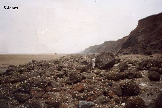
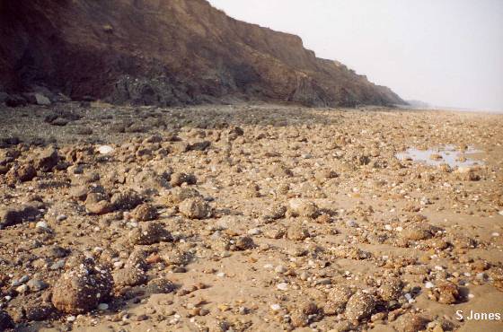
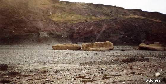
In addition to all of this, closer to the shore across Bridlington Bay is a line or area of boulders supposedly left or deposited by glacial action. This serves as a further barrier to any material trying to make its way to the beach between South Landing (Flamborough) and a point just south of Barmston known to local fishermen as the Barmston Stones. Many of these "stones" are actually medium to large size boulders and a good proportion of them appear to be composed of something resembling black basalt. (Plates 6a & 6b)
There are also examples of Shap Granite and Millstone Grit. All of these types of rock are very hard and easily able to resist the effects of erosion by the sea for long periods of time and they form a most effective barrier to any material being washed onto the beaches by all but the fiercest storms.
As stated in the previous paragraph, Easington has not many fossils in its cliffs except at Dimlington the cliffs are not high and eventually give way to the sand dunes of Spurn Point. Easington to Kilnsea has, however, many deposits of ironstone type rocks and small boulders of the type of deposits found in Lincolnshire and Scunthorpe areas. Some of these boulders contain the fossils of ammonites and the bivalve Pecten. This would seem to indicate that there is at least a possibility that these were deposited among debris and terminal moraine by ice that came from a more westerly direction than that of the more northerly deposits.
Plate 6a
View of boulders on Barmston Beach after a storm.
Plate 6b
View of boulders on beach to the north of Barmston.
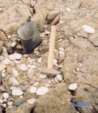
Kilnsea marks the end of this geological journey through Holderness. But to finish, a word of warning - the cliffs are, in places, very prone to mudslides and "slumping", so beware soft mud and tread warily or you may suffer the same fate as the owner of the specimen illustrated in Plate 7!
Plate 7
(c) Hull Geological Society 1999 + 2021