
Humberside Geologist No. 12
The Geology of the Melton Ross Chalk Quarries
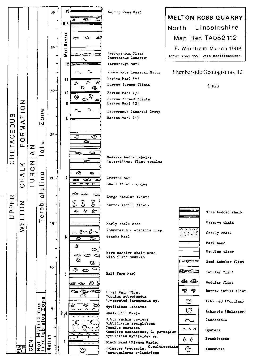
Map No. O.S. 112. Grid Ref. TA 082112 and TA 086115
By
F. Whitham
The very large working chalk quarry operated by W. Singleton Birch & Son Ltd, located on the west side of the A160 (Ref. TA 082112) and the abandoned working opposite on the eastern side of the road (Ref. TA 086115) close to Melton Ross in North Lincolnshire, expose a combined stratigraphical succession ranging from the uppermost part of the Upper Cretaceous, Ferriby Chalk Formation (Upper Cenomanian Black-Band) up to the Melton Ross Marl of the Welton Formation. This marl was previously recorded near to the top of the section in the extreme north of the now abandoned quarry (Smart & Wood 1976). The Black Band has only recently been exposed in the working quarry (TA 082112) and the location was subject to flooding in the winter months of 1995/96.
Unlike some of the other working quarries in the area which are mostly cut in the Cenomanian flintless chalk where the chalk is extracted by drags and ripping, the Welton Chalk at Melton Ross is extremely hard, particularly at and just below the Grasby Marl level, resulting in the need to drill and use explosives to demolish the working chalk faces.
Approximately 3,600 to 3,900 tonnes a day can be quarried and processed with well over half of the production calcined at the very large computer controlled kilns situated on the east side of the A160 road. Most of this production is used in the blast furnaces at the Scunthorpe Steel Mills. Other quarried chalk products are sold as constructional material.
The succession at Melton Ross exhibits exhibits about 39 metres of very hard and medium hard chalks with flint in various forms, interspaced with 13 major marker marls and 2 important marker flints (The First Main Flint and the Ferruginess Flint) see Figure 1. Thes . e markers can be traced in exposures on the North Bank of the Humber at several locations including the very large quarry at Welton Wold (SE 970282) which is the Welton Formation type locality, operated by Croxton & Garry Ltd, and the medium sized workings quarried by Clifford Watts near the top of the Bridle Path just north of South Cave (SE 927327). The exposures here extend from below the Grassby Marl up to the Melton Roes Marl. Some of the other marls and flints are traceable in several smaller pits in the north of the county and are well seen in the cliffs of Thornwick Bay and North Landing.
Fossils although not common do occur at a number of horizons. Commencing at the base of the succession just below the Black Band, the echinoids Holaster trecensis and Camerogalerus cylindricus along with the Terebratulid ornatothyris sulcifera has been recorded at the nearby pits of Nettleton and Eigby, they will no doubt be found at Melton Ross as excavations continue (the horizons are shown on Figure 1). The large rhynchonellid Orbirhynchia multicostata is recorded from the conglomerate below the Black Band.The shelly chalk above the Black Band, up to and just above the Chalk Hill Marle contains the small echinoids Conulus castanea and C. subrotundus , also the inoceramid bivalve Mytiloides labiatus (the Zonal index species), occurring World wide at this horizon. Ammonites have not yet been found in the M. labiatus Zone at Melton Ross but do occur at the same horizon in the Melton Bottoms quarry (north of the Humber) and at other localities. The ammonites include Lewesiceras peramplum and the opined Mammites nodosoides , the former species occurs up to 500 mm in size. At the present time the M. labiatus beds are poorly exposed at Melton Ross but should yield ammonites as further extraction takes place.
Above the Grasby Marl the small bivalve Inoceramus socicalis occurs and the beds over that level, up to the Barton Marls are poorly fossiliferous with only very occasional brachiopods and inoceramids along with rare examples of crushing teeth of the ray Ptychodus mammillaris . Inoceramids of the Inoceramus lamarcki/cuvieri group occur commonly in the beds associated with the Barton Marl the zonal index fossil Terebratulina lata has yet to be recorded at Melton Ross.. The remainder of the exposure includes the 25cm thick Yarborough Marl complex, the Ferruginous Flint (a thick iron stained flint named the Red Bed by earlier workers, traceable in many exposures including Thornwick Bay and North Landing), and almost at the top of the succession in the eastern quarry, the up to 8 cm thick, Melton Ross Marl.
More recently Messrs W. Singleton Birch have commenced operations at one of the previously abandoned quarries at Elsham (TA 038131). Here the Black Band is well exposed and the section seen includes about 3m of beds below the band with a further 5m of chalk above which includes most of the M.labiatus Zone.
References.
Whitham. F. 1991. The stratigraphy of the Upper Cretaceous Ferriby, Welton and Burnham formations north of the Humber, north east England. Proceedings of the Yorkshire Geological Society 48, 227254.
Wood. C.J. 1980. Upper Cretaceous. Pp. 92-105 in Kent. P. British Regional Geology: Eastern England from the Tees to the Wash. 2nd Edition. Institute of Geological Sciences. H.M.S.O., London.
Wood. C.J. 1992. The Chalk. In Gaunt. G.D.,Fletcher. T.J. & Wood. C.J. The geology of the country around Kingston-upon-Hull and Brigg. Geological Survey Memoir, England and Wales, Sheets 80, 89.
Wood. C.J. & Smith. E.G. 1978. Lithostratigraphical classification of the chalk in North Yorkshire, Humberside and Lincolnshire. Proceedings of the Yorkshire Geological Society 42, 263-287.
Safety Precautions.
When visiting these quarries stout boots or wellingtons are necessary and helmets must be worn. Goggles should also be worn when breaking rocks. Keep well clear of quarry faces, beware of falling chalk and crumbling ledges. Safety guidelines issued by the quarry owners should be followed.