
TRANSACTIONS OF THE HULL GEOLOGICAL SOCIETY
RECENT SECTIONS IN EAST YORKSHIRE GLACIAL BEDS.
T. SHPPARD, M.Sc., F.G.S.
The statement that glacial deposits were uninteresting,
amazing as it was to me then, would be still more so today. Led by Professor
Kendall, the late G. W. Lamplugh, local geologists, and a whole army of others
from different parts of the country and abroad, we have examined the wonderful
series of glacial beds which exist in the East of Yorkshire, and no doubt the
key to our knowledge of what happened in England during the great Ice Age is
to be gained by an examination of the drift deposits of this area. The buried
cliff extending from Hessle to Sewerby, the fine moraine, transported masses
of Speeton clay lifted on to the top of Flamborough Headland; the wonderful
sections in the basement Boulder clay, the purple Boulder clay and the Hessle
clay, seen to such excellent advantage on the coast, and the fine series of
gravel deposits in Holderness, all assist in giving facts relating to the
various changes which took place in the more recent of our geological epochs.
In
addition to the sections exposed by the action of the North Sea, various
railway cuttings and pits for the supply of gravel for building and other
purposes, have enabled us to get a very clear idea of the strata resting upon
the chalk. Particularly in the years since the war, new sections have been
made and old ones have disappeared.
The
gravels in different areas, as with the different beds of Boulder clay,
contain shells, mammalian remains, and erratic blocks, which vary in different
districts.
In
our young days we used to sing about the 'ever- lasting hills,' but recent
experience shows that –
In my
'Geological Rambles in East Yorkshire,'
which I published more years ago than I care to remember, I gave an
illustration of Brandesburton Barfe, a large rounded gravel mound in central
Holderness, a favourite hunting ground for derived glacial shells, erratic
blocks, and an occasional mammoth tooth. Today the hill has disappeared from
the landscape, having been carted away piece-meal by the Beverley Corporation,
which has mixed the gravel with Hull-made cement, and in this way has housed a
large number of its inhabitants. In the same vicinity large and important
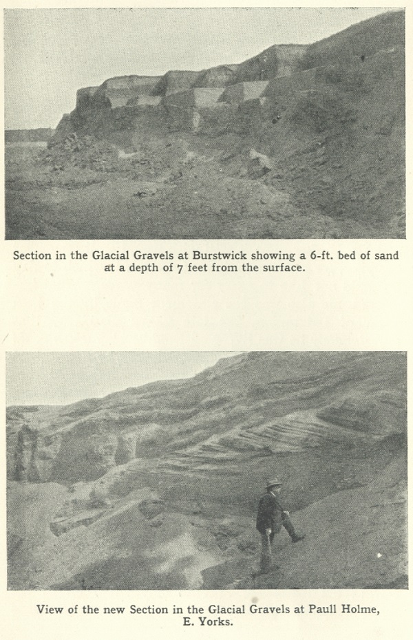
sections have been made in other hills, and at Paull are large holes in the
glacial
mound which originally diverted the course of the
stream from flowing due east, to south-east.
The well-known Burstwick Gravel Pits have been
considerably extended in many directions, resulting in much of the hilly
ground here being reduced to the level of the surrounding fens.
A study of these various beds gives interesting
results. In The Naturalist for February, 1922, I gave details of some
recent glacial sections in Holderness, and then described deposits at
Skirlaugh, Coney Garth, Leven, Keyingham, Catwick and other places.
In Clement Reid's
'Geology of Holderness', published in 1885, are some of the first detailed
descriptions of the Holderness gravels, which that author considered to be
interglacial, as they certainly rested upon Purple Boulder Clay, and for the
most part were covered by the less compact foxy-red Hessle Boulder Clay, the
erratics in each deposit indicating a different source of origin.
More recent workers, however, following Lamplugh,
consider that the gravels were deposited during an interval between the
oscillations of the ice front of the great North Sea glacier. His experience
of glacial phenomena in Alaska, and other places, showed that such
oscillations had actually taken place; and, in Spitsbergen particularly, Sir
Martin Conway and Professor Garwood have described glacial mounds containing
erratics, Arctic shells, and bones of whales and other animals, which had been
over-ridden precisely as our Holderness mounds seem to have been.
With regard to the mammalian remains in the gravels,
recent excavations have produced quite a large number, some from localities
where hitherto they have not been recorded, as, for example, at Paull and in
one of the Brandesburton pits. It would seem that these bones of extinct
animals occur fairly deep down in the gravel, and while reindeer, rhinoceros,
walrus, seal, bison, mammoth, and animals of that type have been identified,
by far the greater number of bones found in recent years have been of Bos
primigenius, or great ox, the horn cores, leg bones and vertebrae of which
seem particularly numerous, and indicate that this species was fairly common
in the neighbourhood during the glacial period. It is possibly due to modern
methods of quarrying, which enable the sections to be cut deeper, that more
bones are nowadays being found.
These additional sections have also assisted our
investigating an interesting problem first raised by Prestwich in his paper
dealing with the Holderness Gravels, so long ago as 1861. This relates to the
occurrence in tremendous profusion of a freshwater bivalve, Corbicula
(or Cyrena) fluminalis. This species occurs to-day in the Nile and some
Asiatic rivers, but has long been extinct in this area. In the old Kelsey Hill
Pit,
excavated for the Hull and Barnsley Railway, the
species occurred literally in thousands. It is also numerous in the adjoining
quarry at Burstwick. The shell itself is fairly thick, is almost invariably
found whole, and has clearly not been transported any great distance. This led
to the assumption that it probably occupied the old estuary of the Humber,
which before the Ice Age ran out to sea across Holderness where Withernsea now
is. The difficulty here, however, is that the shelly gravels rest upon purple
Boulder clay, left by the ice which filled the Humber and should, therefore,
have buried the Humber fauna beneath the clay! On the advance of the
ice, marine shells dragged from the bed of the North Sea were commingled with
the fresh-water Corbicula, and the two occur together in the gravels,
with pholas-bored
stones and other evidences of marine life. An odd shell of Corbicula
has been recorded in the North Lincolnshire gravels, and at Paull, but for
many years East Yorkshire geologists have been endeavouring to confirm these
records, without result.
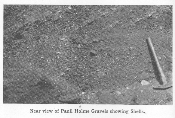
In the new sections at Paull, which are particularly
shelly in patches, the molluscan remains vary from mature oysters to Bullae
and other of our smallest and most fragile shells. Here, however, after hours
of search on the part of several local geologists, not a single fragment of
Corbicula has been seen. This is all the more remarkable when it is borne
in mind that the gravel at Paull is practically on the same line, east and
west, as the old course of the Humber, and is only a distance of three or four
miles from the other beds where the shells occur so abundantly.
Recent engineering operations at Filey, towards the
north end of our fine glacial sections, and at Salt End, the southern
extremity, have provided an interesting problem with regard to the former
levels of this country before, during, and since the Great Ice Age. The fact
that the pre-glacial chalk-strewn beach at Hessle, and near Sewerby, the
southern and northern extremities of the pre-glacial cliff line respectively,
are practically on the same horizon as the present beach, has always led one
to assume that there had been no great changes in the levels of this country
since pre-glacial times. (note - A record of a so-called raised beach at Cat
Nab, near Saltburn, was proved by Lamplugh to be of the kitchen-midden type,
and of no geological significance.)
During the past few months a boring has been put down
near the Gasworks at Filey, which seems to have been placed precisely in the
centre of a very deep ravine, which, in pre-glacial times, flowed east into
the North Sea at Filey; probably this was the old course of the Derwent. The
advancing glaciers entirely filled this ravine with drift, and in the recent
search for water, this drift-filled hollow was penetrated to a depth of no
fewer than 189½ feet from the surface, and as this is 138 feet above
sea-level, it means that if the borings can be relied upon, 71½ feet of this
ravine occur below sea-level. This is a much greater depth than would
ordinarily be the case by ordinary river erosion, consequently the evidence of
this boring and of an adjoining boring recorded by the late C. Fox Strangways,
indicates that formerly the land at Filey was at a higher level than it now
is.
With regard to Salt End, the London and North Eastern
Railway Company at present is dredging the Humber near the shore there. The
dredgers are removing the different deposits foot by foot, so that by
examination of the material brought up, it has been possible to prepare a
geological section of the deposits. I have recently had sent to me a large
number of hazel nuts taken from the peat at Salt End at a depth of 35 feet
below O.D. I understand that the dredger is also bringing up Boulder Clay in
patches, so that it would seem at this depth the peat has occupied hollows in
the glacial beds, as indeed it does on a higher level in other parts of
Holderness. In view of the importance of this depth, I have made particular
enquiry from the Engineering staff of the Railway Company, and I am assured
that the measurements can be relied upon. This being so, it is to be inferred
that the land level when this peat grew must have been considerably higher
than it now is. In view of this, the post-glacial changes that have taken
place in this district in comparatively recent times must have been on a much
more gigantic scale than had previously been supposed. This is, of course,
assuming that the peat is in situ,
but as the site is near the
out-fall of an old fleet drain, one must be a little cautious before forming
very definite conclusions.
I am informed that the section, as dredged, consisted
first of 2 feet of dirty gravel, then 3 feet of greasy black clay, followed by
5 feet of Boulder clay, and 14 feet of clean sand; this section beginning at 5
feet below low water spring tides. When dredging in the Alexandra Dock, which
is not far away, peat is occasionally brought up in the buckets from a depth
of 22 feet below O.D., a difference of 13 feet in depth between Salt End,
which is only a distance of about 2½ miles away.
Registered Educational Charity No. 229147