
Hull Geological Society
Late Devensian glacigenic
sediments exposed in coastal cliffs at Danes’ Dyke and South Landing
(Flamborough Head) East Yorkshire: A Field Guide
For the 52nd
BSRG ANNUAL GENERAL MEETING
1. Introduction
The sites to be visited can be found on the following
maps:-
OS Explorer 1:25,000 Sheet 301 Scarborough, Bridlington &
Flamborough Head
OS Explorer 1:25,000 Sheet 295 Bridlington, Driffield &
Hornsea
BGS 1985. 1:50,000 Series. England and Wales Sheets 55 &
65. Flamborough and Bridlington. Solid and Drift Provisional Edition.
The coastal cliff exposures of Holderness and Flamborough
Head, East Yorkshire (Figure 1), provide extensive exposures, but of variable
quality, in glacial sediments deposited during the Late Devensian (Dimlington
Stadial) between approximately 22,000 and 15,000 cal. yr BP. During this
interval the North Sea Lobe of the last British-Irish Ice Sheet advanced down
what is now the western North Sea, as far as north Norfolk, depositing a thick
and varied succession of glacigenic sediments (Figure 2). See Catt (2007) for a
regional review of the glaciation of the district and Bateman
et al. (2011) for a
re-evaluation of the chronology of the typesite of the stadial at
Dimlington, south Holderness.
The sites on Flamborough Head (Figures 1 and 3), Danes’
Dyke and South Landing, provide evidence of palaeoenvironments prior to, and
during, the advance of the North Sea Lobe preserved within valleys cut into the
chalk bedrock of the headland. Ongoing research
by the Flamborough Quaternary Research Group, Hull Geological Society,
has recognised the potential of these sites, apparently forgotten since the late
19th century (Lamplugh, 1891), to provide significant new dating
control on the initial advance of the North Sea Lobe into eastern England. Work
at the sites is being prepared for publication (Heppenstall
et al. in preparation).
2. DANES’ DYKE
Coastal cliff section at TA 215 692.
Recent work by the Flamborough Quaternary Research Group
has focused on both Danes’ Dyke and South Landing (Figure 3) as chalk is found
close to modern sea level in the base of valley forms now buried beneath
substantial thicknesses of glacigenic deposits. Initial work suggested the
possibility that chalk rich gravels resting on bedrock at both sites could be
correlatives of the Ipswichian interglacial marine beach deposit known from the
classic site at Sewerby, just a few kilometres to the west (Catt, 2007).
However, this has proved not to be the case but the earliest deposits are
significant in providing new chronological information for the initial advance
of the North Sea Lobe of the last ice sheet in eastern England during the
Dimlington Stadial. Final optically stimulated luminescence (OSL) dates are
eagerly awaited from both these sites.
At Danes’ Dyke the presently best exposed section is to
the west of the modern valley (Figures 4 and 5). Chalk bedrock at the base of
the relatively narrow valley form appears tectonised and probably also
brecciated by periglacial processes. A lower, coarse, generally angular chalk
clast diamicton, with a coarse silt matrix, overlies bedrock (Figures 5 and 6).
This passes upwards into a better bedded smaller clast size diamicton, again
with a coarse silt matrix, and discrete thin beds of coarse silt. Bedding within
the units dips at low angles towards the valley centre. This unit has a maximum
thickness of 2.5m. The generally angular nature of the almost exclusively chalk
clasts in these beds, position flanking the valley side and coarse silt matrix
suggests these units are periglacial slope deposits (geliflutates) with an
aeolian silt (loess) matrix. Similar material is widely known from the chalk dry
valleys of the Yorkshire Wolds. Loessic silt from a similar deposits at
Eppleworth (west of Hull), and beneath weathered Skipsea Till, has been dated by
TL to 17.5 ± 1.6 ka (Catt, 2007) and a similar age is proposed within the
Dimlington Stadial of the Late Devensian for the deposit at Danes’ Dyke. Some
large boulders of Jurassic? sandstone are present in the lower, coarser,
gelifluction deposit. They may be remnants of an earlier glacial deposit that
once filled the valley.
Overlying the gelifluction diamicton are up to 1.75m of a
coarsening upward sequence of laminated muds and laminated and rippled sands
(Figures 6 and 7). These sediments appear to by the earliest glacial sediments
and are interpreted to be proglacial lacustrine deposits. Their presence
suggests that ice must have been present to the south, in what is now
Bridlington Bay, to block drainage in the valley. An OSL dating sample has been
taken from the glacilacustrine sands.
A succession of ~25m of further glacigenic sediments
overlies the glacilacustrine beds (Figure 7) composed of multiple diamicton and
gravel/sand units. Whilst these units have yet to be described in detail the
matrix colour of the diamictons is similar to the Skipsea Till (cf LFA 1,
Skipsea Till of the Barmston sections). Diamicton 1 overlies the glacilacustrine
beds and appears to incorporate rafts of the sand (Figure 7). Clast fabrics in
the unit indicate ice flow from the east north east, oblique to the likely
valley orientation. Further work is required to understand the complex glacial
stratigraphy at this site in comparison to other nearby sites.
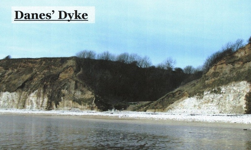
Figure 4. Danes’ Dyke. Valley form cut
into chalk bedrock. The modern valley is excavated through periglacial and
glacial sediments. Cliff height ~30m.
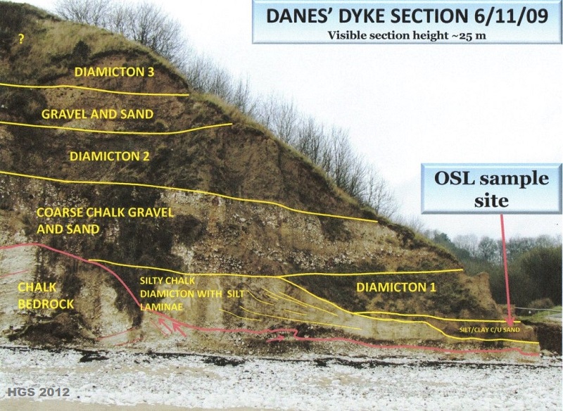
Figure 5. Danes’ Dyke west section. Chalk
bedrock overlain by periglacial sediments and a complex sequence of glacigenic
deposits.
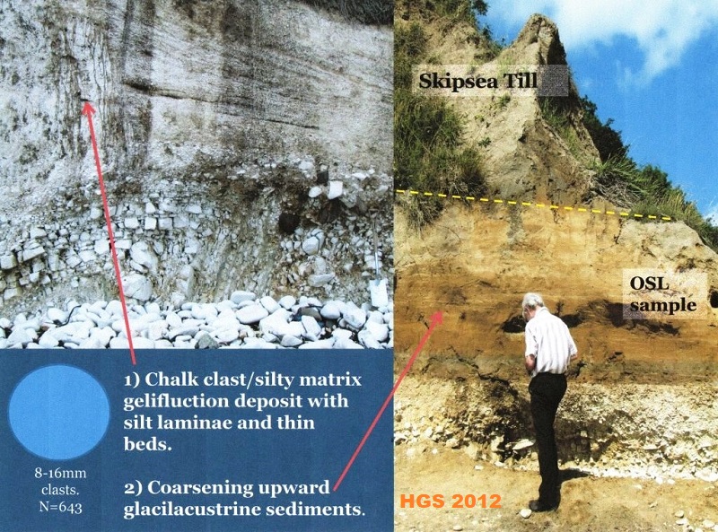
Figure 6. Detail of the Danes’ Dyke west
section. Locally derived periglacial slope deposits overlain by glacilacustrine
muds and sands and Skipsea Till. OSL dating site shown.
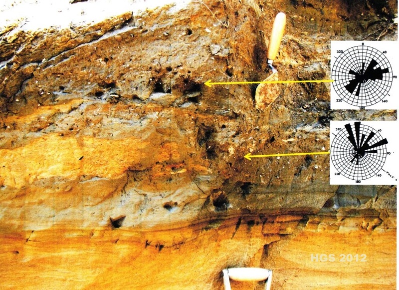
Figure 7. Danes’ Dyke west section. Detail
of the contact between glacilacustrine sediments and overlying Skipsea Till
(Diamicton 1). Trowel for scale.
3. SOUTH LANDING
Coastal cliff sections between TA 233 692 and TA 230 692.
A much wider valley form is present at South Landing
(~230 m. Figure 8) just 2 kilometres east of Danes’ Dyke, and sediments are
exposed to both the east and west of the modern valley.
To the east erratic poor, coarse, chalk gravels are
exposed and are up to ~10m thick (Figure 9). The lower parts are dominantly
cobble/boulder gravels, typically unorganised, though occasionally displaying
inverse grading. Bedding surface dips are towards the southwest quadrant. The
upper division is less coarse and has more quartz sand beds present. In this
unit bedding dips (and probably some medium sized cross beds) suggest
palaeoflows towards the northwest. This deposit is enigmatic. The coarseness and
thickness of the unit allied to the presence of probable debris flow deposits
suggest a provisional interpretation as some form of proximal glacigenic fan.
Certainly it does not resemble periglacial deposits known from Danes’
Dyke, Sewerby and many other sites on the Yorkshire Wolds. An OSL dating sample
was taken from quartz rich sands of the upper part of this deposit to help place
it in the emerging chronology.
A very different suite of erratic rich chalk gravels is
present to the west of the modern valley (Figure 10). Here the gravels rest on a
slightly irregular chalk platform at a similar elevation (approximately 2.5m OD)
to that beneath the Ipswichian interglacial beach at Sewerby (Catt, 2007).
However, the gravels at South Landing do not have any of the characteristics of
the beach gravels at Sewerby: the chalk clasts at South Landing are poorly
rounded, erratics make up nearly 50% of the assemblages, there are no mammalian
or marine molluscan fossils known. The gravels at South Landing are up to 3m in
thickness and clast sizes fine upwards, and quartz rich sand beds become more
common upward to. A cryoturbated surface is sometimes visible below the top of
the gravels (Figure 10) and frost shattered chalk cobbles can be seen in some of
the large calcreted gravel and sand blocks on the beach in front of the section.
Though field relationships are difficult, due to slumped material at the cliff
base, the erratic rich gravels of the western exposures are believed to be
younger than the erratic poor gravels to the east. The erratic rich character of
the gravels in the western exposure, allied to the northerly palaeocurrent
directions, determined from clast imbrications (Figure 10), indicates these
deposits are glacifluvial outwash gravels derived from an ice margin that was
located to the north of the site.
An hiatus in the sequence is indicated by the periglacial
surface near the top of the gravels. Above these deposits are poorly exposed
glacilacustrine facies, gravels and sands and finally diamictons, the whole
being over 20min thickness (Lamplugh, 1891). Again, the matrix colour of
diamicton, where exposed, suggests it is a representative of the Skipsea Till,
though other units may be present high in the eastern cliff (Lamplugh, 1891) and
are the subject of further research. OSL dating samples have been taken from the
top of the western gravels and sands, and from a unit of glacifluvial sand high
in the western cliffs. Results are eagerly awaited!
Although chalk bedrock is exposed close to modern sea
level in the valleys at Danes’ Dyke and South Landing there appears to be no
preservation of last interglacial beach gravels at these sites. Though the chalk
platform beneath the gravels on the west side of South Landing may be a modified
marine abrasion platform, no interglacial marine deposits are preserved on it.
Despite this the earliest deposits preserved within the bedrock-cut valleys are
significant in allowing OSL dating which may provide a closer chronology for the
advance of the North Sea Lobe of the last ice sheet as it advanced into eastern
England.
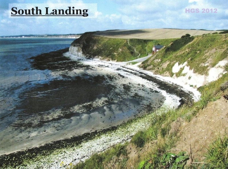
Figure 8. South Landing valley form. Again the modern
valley has excavated the older valley fill. Cliff height ~30m. Note steep chalk
cliff on the west (left) side of the valley. The white cliff to the east (right)
is composed of coarse chalk gravels. Slumping in the upper cliff conceals thick
glacigenic sediments.
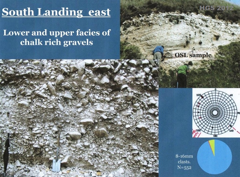
Figure 9. South Landing east sections. Erratic poor,
coarse lower and finer upper chalk gravels. Spade and figures for scale. Pie
chart: blue=chalk, red=flint, green=other erratics. Proximal glacigenic fan
deposit? OSL dating site noted.
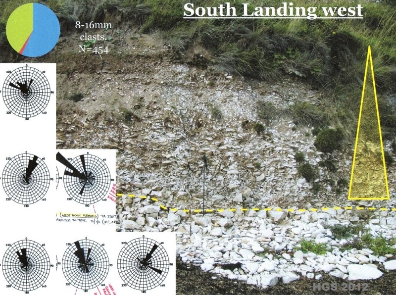
Figure 10. South Landing west section. Erratic rich chalk
gravel on bedrock. Upper portion of the unit is cryoturbated, representing a
periglacial land surface, with finer grained gravels above. Walking pole for
scale. Glacifluvial outwash gravel. An OSL dating sample was recovered from
close to the top of the unit at an immediately adjacent section.
4. Acknowledgements
For help with the ongoing research on Flamborough Head
the FQRG would like to thank all other FQRG/HGS members who have helped at the
sites; Mark Bateman and Dan Hartmann (Sheffield University) for the ongoing OSL
dating programme; Al Gemmell and Audrey Innes (Aberdeen University) for
granulometry; Lynda Howard for
searching for beetles and chironomids; Ian
Candy (RHUL) for examining carbonate cements;
John Catt, Colin Whiteman, John Boardman, Julian Murton, Della Murton,
Emrys Phillips for advice and discussions.
5. Literature Cited
Bateman, M.D., Buckland, P.C., Whyte, M.A., Ashurst,
R.A., Boulter, C. and Panagiotakopulu, E. 2011. Re-evaluation of the Last
Glacial Maximum typesite at Dimlington, UK.
Boreas
40, 573 – 584.
Catt, J.A. 2007. The Pleistocene glaciations of eastern
Yorkshire: a review. Proceedings of the
Yorkshire Geological Society 56,
177 – 207.
Heppenstall, I. and ten others (In preparation) Lost and
found: the pre-Skipsea Till palaeo-valley fill sediments of Flamborough Head,
and their significance for dating the advance of the last ice sheet in eastern
England.
Lamplugh, G.W. 1891. On the drifts of Flamborough Head.
Quarterly Journal of the Geological
Society of London 47, 384 – 431.
Penny, L.F. and Catt, J.A. 1967. Stone orientation and
other structural features of tills in East Yorkshire.
Geological Magazine
104, 344 – 360.
Copyright - Hull Geological Society 2026
Registered Educational Charity No. 229147