
Hull Geological Society
Late
Devensian glacigenic sediments exposed in coastal cliffs at Barmston
(Holderness), Danes’ Dyke and South Landing (Flamborough Head) East Yorkshire: a
field guide, by the Flamborough Quaternary Research Group of the Hull Geological
Society: Colin Clark, Rodger Connell, Derek Gobbett, Dennis Haughey, Ian
Heppenstall, Mike Horne, Stuart Jones, Brian Kneller, Chris Leach, Paul Richards
and Rod Towse.
For the
Sedimentology: Process and Product Conference at the University of Hull on
Sunday 7th October 2012.
Copyright Hull
Geological Society 2012 and 2026.
1.
Introduction.
The sites to be
visited can be found on the following maps –
OS Explorer 1:25 000
sheet 301, Scarborough, Bridlington and Flamborough Head.
OS Explorer 1:25 000
sheet 295, Bridlington, Driffield and Hornsea
BGS 1985 1:50 000
series, England and Wales sheets 55 and 65, Flamborough and Bridlington, solid
and drift provisional edition.
The coastal cliff exposures of
Holderness and Flamborough Head, East Yorkshire, provide extensive exposures of
variable quality, in glacial sediments deposited during the Dimlington Stadial
of the Late Devensian, between approximately 22 000 and 15 000 calendar years
before present. During this interval the North Sea Lobe of the last
British-Irish Ice Sheet advanced down what is now the western North Sea, as far
as north Norfolk, depositing a thick and varied succession of glacigenic
sediments. See Catt (2007) for a regional review of the glaciation in the
district and Bateman et al. (2011) for
a re-evaluation of the chronology of the type site of the stadial at Dimlington,
southern Holderness.
At Barmston, northern
Holderness, we are able to investigate the sedimentology and structural geology
of a range of glacigenic facies: diamictons of the Skipsea Till and laminated
muds, sands and gravels deposited during the advance and retreat episodes of the
North Sea Lobe ice sheet towards the close of the period. The site was studied
by Evans and Thomson (2010), as part of a wider study in Holderness.
The sites at Flamborough Head,
Danes’ Dyke and South Landing, provide evidence of palaeoenvironments before and
during the advance of the North Sea Lobe, preserved within valleys cut into the
Chalk bedrock of the headland. Ongoing research by the Flamborough Quaternary
Research Group of the Hull Geological Society has recognised the potential of
these sites, apparently forgotten since the late 19th century
(Lamplugh 1891), to provide significant new dating control on the initial
advance of the North Sea Lobe into eastern England. Work at the sites is being
prepared for publication (Heppenstall at
al. 2010).
2. Barmston.
Coastal cliff sections between TA172579 and TA 169600.
The coastal cliffs at
Barmston (figure 3) are low and undulating, reaching a maximum height of 10m OD.
Due to their ‘soft’ nature erosion rates can be rapid and average some 2m per
year. The most recent published research on the glacial sediments here, and more
widely in Holderness, is that of Evans and Thomson (2010). They have proposed
that the sediments represent a series of minor readvances of the North Sea Lobe,
each of which tectonised pre-existing deposits to produce a subglacial
glacitectonite facies together with subaqueous outwash sediments, forming ridges
at the ice margin. They identified three major litho-facies associations (LFA1,
LFA2 and LFA3) within these depositional systems and these are usually visible
in the Barmston Cliffs.
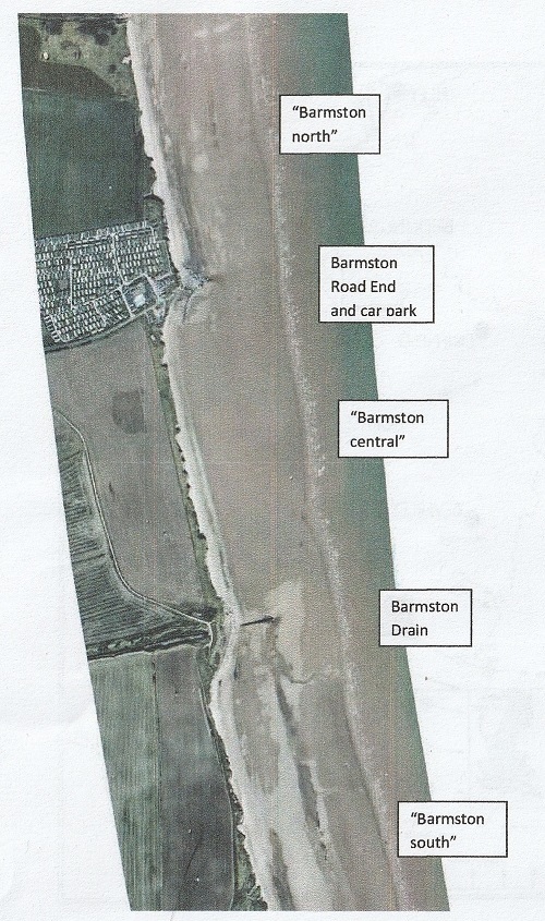
Figure
3. Air photograph of much of the Barmston section. Approximately 2km in length.
Note the increased erosion south of Barmston Road End and Barmston Drain and
locally increased erosion where gravel and sand bodies, loaded into Skipsea
Till, have been preferentially washed out of the cliff. [We thank Brian Kneller
of the FQRG for obtaining this photograph and Neil McLachlan of the East Riding
of Yorkshire Council for giving permission for its use.]
Skipsea Till
diamicton makes up the lower parts of nearly all the cliff exposures with from
about 1m to 6m visible. It is typically a matrix supported massive diamicton of
dark greyish brown colour (Catt 2007) though subtle colour variations are seen.
Stratified and laminated facies are also recorded and both ductile and brittle
deformation structures can be seen, indicating stress from the north or
northeast mirroring the regional clast fabrics. Attenuated lenses and rafts of
grey and reddish brown silty/sandy clay can also be seen in the section possibly
derived from Mesozoic bedrock lithologies to the north.
Of particular
interest is the undulating upper surface of Skipsea Till (LFA1). Whilst reaching
over 6m above beach level in some locations it is also seen just above the beach
in others (figures 7 and 16). This feature has been interpreted as either an
irregular surface due to meltout and slumping as a surge lobe decayed together
with possible squeeze ridges (Eyles et al 1994, Evans et al. 1995) or possibly
as subtle proglacial deformation produced by re-advance, possibly that of the
Withernsea Till ice (Evans & Thomson 2010).
Though not mentioned in any detail
by Evans and Thomson (2010) Skipsea Till (LFA1) displays a very conspicuous
sub-vertical joint system along the Barmston Cliff section, and indeed at other
sites on the Holderness Coast. Penny and Catt (1967) first recorded these
features and interpreted them as conjugate sheer joints formed by stress from
the northeast during a small re-advance to form the “Barmston Push Moraine”
(figure 7). Recent measurement of the sub-vertical joints along this section in
September 2012 (figures 8 and 9) failed to replicate the orientations obtained
by Penny and Catt. The previously visible joints, commonly present throughout
the entire exposed thickness of the diamicton, do not show any vertical
displacement of diamicton stratification and are commonly seen within apparently
diapirically intruded diamicton ‘columns’.
This, together with the loaded bodies of gravel and sand which commonly overlie
the diamicton (figures 7, 11 and 13) suggest its upper part was saturated at
deposition. These features combined suggest the joints formed ‘late’ and are the
product of dewatering and compaction of the diamicton.
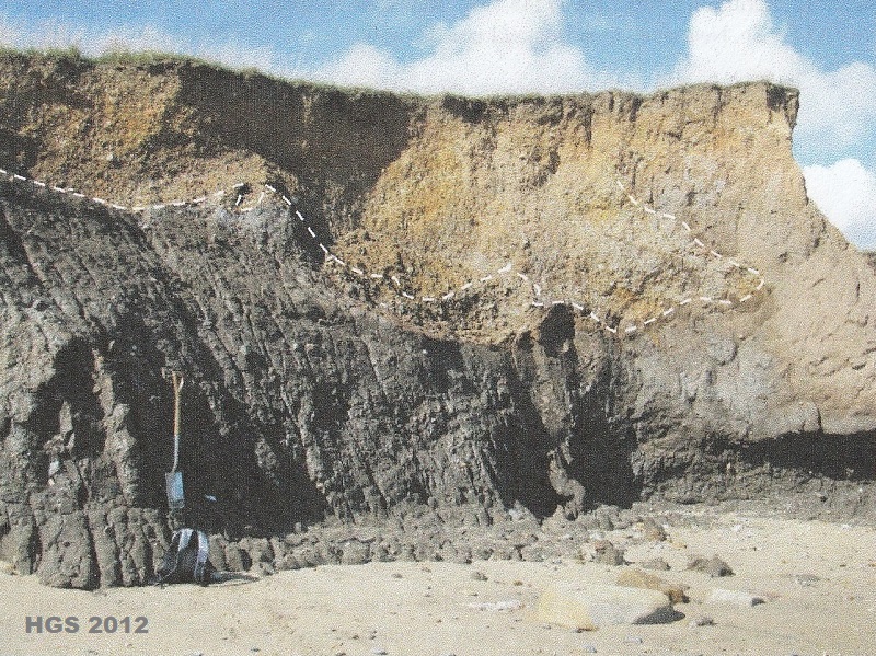
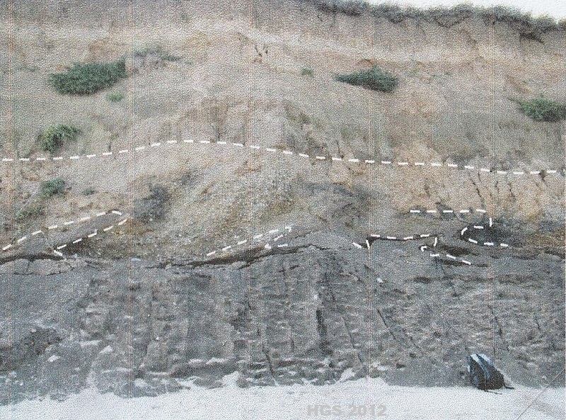
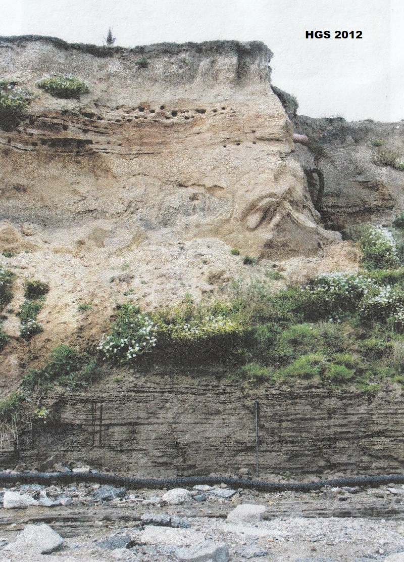
Figure
7. Well jointed Skipsea Till (LFA1, Dmm) at TA1730 5792 (the spade for scale is
1m long). Barmston south. Note the irregular loaded contact with overlying
gravels and sands (LFA3).
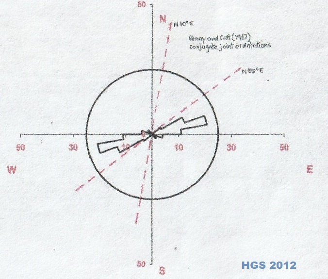
Figure 8. Sub-vertical joint orientations measured in
the Skipsea Till at TA 1730 5791, close to Catt and Penny’s 1967 “push moraine”
site. N = 60. The orientation of Catt
and Penny’s conjugate shear joints are shown in red for comparison with the FQRG
data from September 2012.
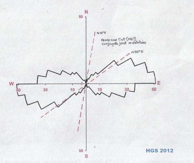
Figure 9. Sub-vertical joints measured along the
Barmston section in the Skipsea Till from TA 1730 5791 to TA 1715 to 5881.
N = 305.
The FQRG data is from September 2012. The
orientation of Catt and Penny’s conjugate shear joints are shown for comparison.
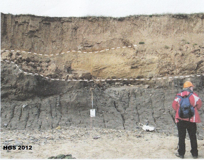
Figure
11. Barmston central TA 1713 5883 (rucksack for scale). Deformation structures
at the top of the Skipsea Till overlain by gravels and sands, with fine grained
rhythmites high in the section.
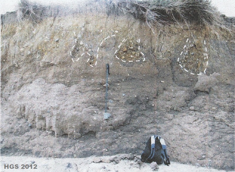
Figure
13. Barmston central TA 1705 5916 (rucksack for scale). Gravel pendant
structures. Saturated till loaded by overlying sandy gravels.
Figure
10. Barmston south, TA 1722 5820 (spade and geologist for scale). Well jointed
Skipsea Till overlain by gravelly sand and a further diamicton unit. Is this
subglacial channel fill or proglacial outwash overlain by a minor re-advance
till?
In most of the
available exposures LFA1 diamicton is overlain by small and large bodies of
gravels and sands (LFA3 of Evans and Thomson 2010) (figures 7, 11 and 13). These
range from large pods to smaller ‘pendant’ structures (figure 13). All appear to
have been loaded into originally saturated, plastic, diamicton. LFA3 can be
found both where the diamicton is low or high in the cliff and locally (as in
figure 11) the deformation structures appear to be overturned in a consistent
northward direction.
Along the Barmston
central and northern sections LFA1 and LFA3 are typically overlain by a sequence
which appears to ‘drape’ a pre-existing topography. The sequence coarsens
upwards from sand/silt/clay rhythmites (LFA2b of Evans and Thomson 2010) (see
figures 5, 12 and 16) into massive and de-watered sands, rippled sands (LFA2a)
and finally into sandy and gravelly clinoforms (LFA2a and LFA3) marking
progradation of subaqueous fan bodies within the glacilacustrine basins (figures
16, 17 and 18). At one site (figure 14) low angle thrusts disrupt bedding within
the LFA2b rhythmites and may be rooted in deformation structures in the
underlying diamicton. It is as yet unclear if this deformation is due to loading
and compaction during deposition of the units or possibly gentle proglacial
deformation? Occasionally ice wedge casts can be seen penetrating downwards into
this sequence from near the present surface indicating subsequent permafrost
development.
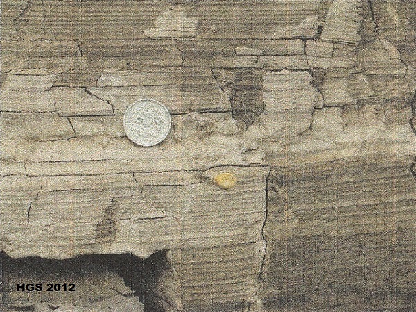
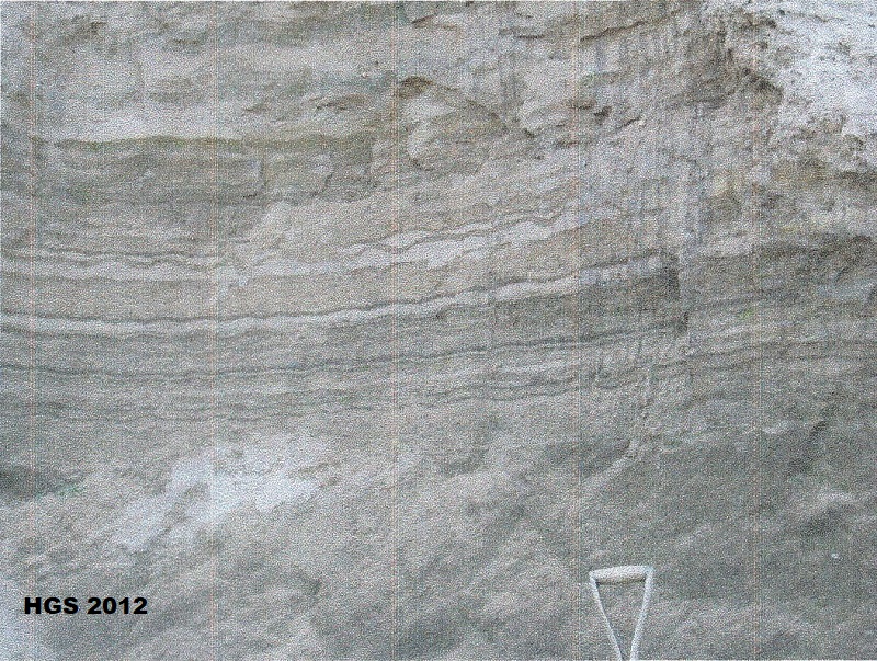
Figure
12. Barmston Central TA 1715 5870 (pound coin for scale). Millimetre scale
rhythmites with a small dropstone. Bed LFA2b of Evans and Thomson (2010).
Figure
16. Barmston Road End. TA 1710 5935 (walking pole for scale). Compare with
figure 5. The sequence from the base is: Skipsea Till is exposed below the
beach. Overall coarsening upwards sequence within glacilactustrine basin fill.
Clay/silt rhythmites low in the section contain small pebble rich horizons and
isolated drop stones. Overlain by gravelly sands with conspicuous load
structures. These are overlain by better bedded sands to the cliff top.
Figure
17. Barmston North TA 1708 5940 (spade handle for scale). Rippled sands in the
central part of the coarsening upwards glacilucustrine sequence.
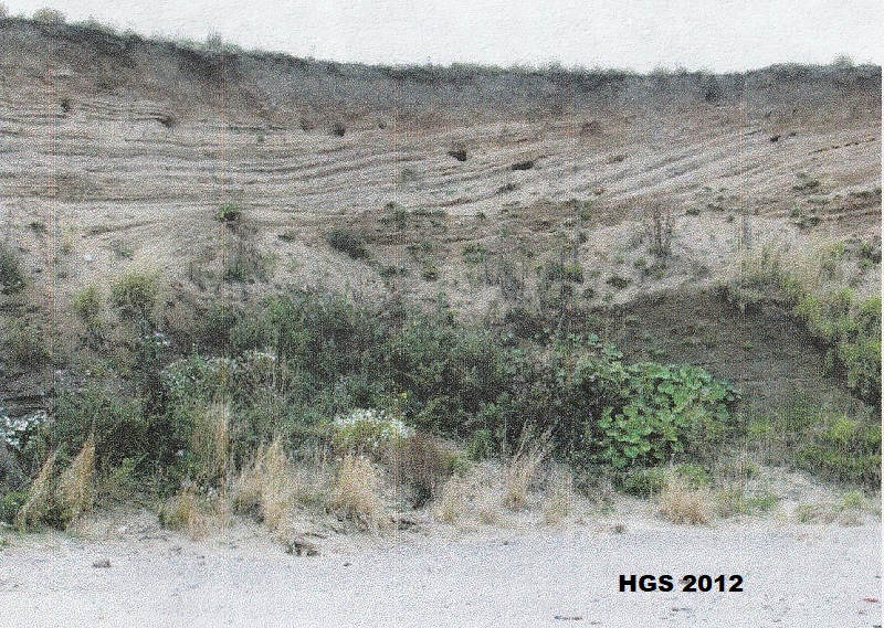
Figure 18. Barmston north TA 1705 5968 (section about
5 m high).
Rhythmites and sands overlain by low angle
clinoforms. Subaqueous outwash fan terminating the basin fill.
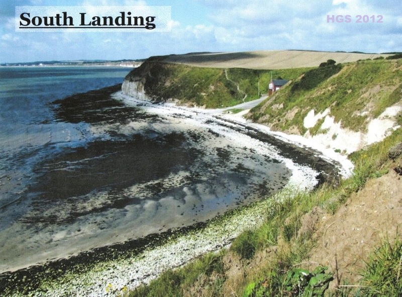
3 Danes’ Dyke.
Coastal cliff section at TA 215 692.
Recent work by the
Flamborough Quaternary Research Group of the Hull Geological Society has focused
on both Danes’ Dyke and South Landing (Figure 19) as Chalk is found close to
modern sea level at the base of valley forms now buried beneath substantial
thicknesses of glacigenic deposits. Initial work suggested the possibility that
Chalk rich gravels resting on the bedrock at both sites could be correlatives of
the Ipswichian interglacial marine beach deposit known from the classic site at
Sewerby (Catt 2007). However, this has been proved not to be the case. The
earliest deposits are significant in providing new chronological information for
the initial advance of the North Sea Lobe of the last ice sheet in eastern
England during the Dimlington Stadial. Final optically stimulated luminescence
(OSL) dates are eagerly awaited for both these sites.
At Danes’ Dyke the
presently best exposed section is to the west of the modern valley (figures 20
and 21). Chalk bedrock at the base of the relatively narrow valley form appears
tectonised and probably also brecciated by periglacial processes. A lower,
coarse, generally angular chalk clast diamicton, with a coarse silt matrix,
overlies bedrock (figure22). This passes upwards into a better bedded smaller
clast size diamicton, again with a coarse silt matrix and discrete thin beds of
coarse silt. Bedding within the units dips at low angles towards the valley
centre. This unit has a maximum thickness of 2.5m. The general angular nature of
the almost exclusively Chalk clasts in these beds, the position flanking the
valley side and the coarse silt matrix suggests that these units are periglacial
slope deposits (gelifluctates) with an aeolian silt (loess) matrix. Similar
material is widely known from the Chalk dry valleys of the Yorkshire Wolds.
Loessic silt from similar deposits at Eppleworth Quarry (west of Hull) and
beneath weathered Skipsea Till, has been dated by thermoluminescence to 17.5 +/-
1.6 ka (Catt 2007) and a similar age is proposed within the Dimlington Stadial
of the late Devensian for the deposit at Danes’ Dyke. Some large boulders of
(probably) Jurassic sandstone are present in the lower, coarser, gelifulction
deposit. They may be remnants of an earlier glacial deposit that once filled the
valley.
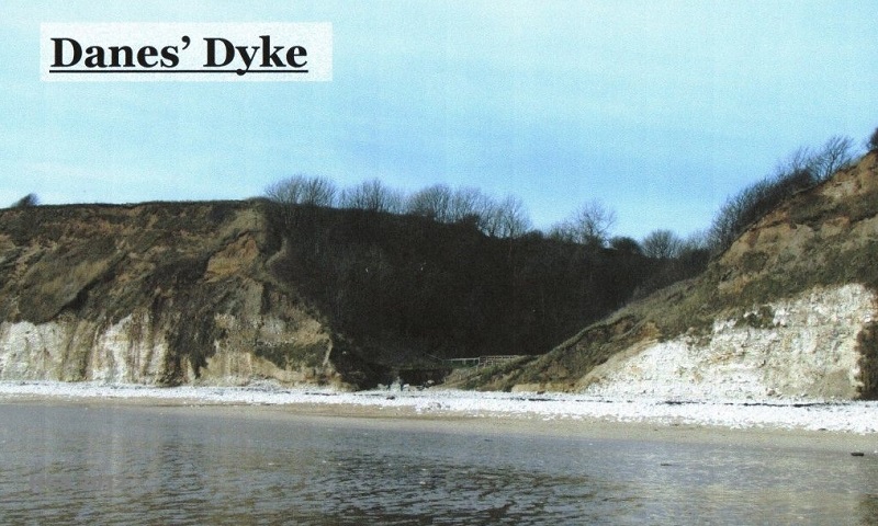
Figure
20. Danes’ Dyke (cliff height about 30m). Valley form cut into Chalk bedrock.
The modern valley is excavated through periglacial and glacial sediments.
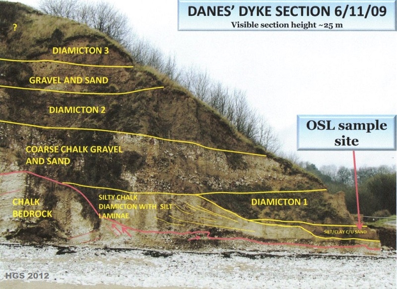
Figure
21. Danes’ Dyke, west section. Chalk bedrock overlain by periglacial sediments
and a complex sequence of glacigenic deposits.
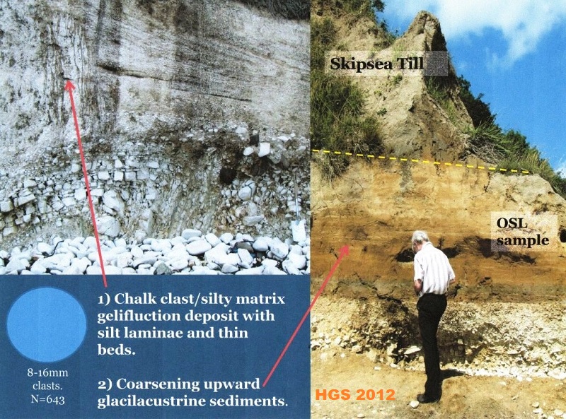
Figure
22. Detail of Danes’ Dyke west section. Locally derived periglacial slope
deposits overlain by glacilacustrine muds and sands and Skipsea Till. OSL dating
sample site shown.
Overlying the
gelifluction diamicton are up to 1.75m of a coarsening upward sequence of
laminated muds and laminated and rippled sands. These sediments appear to be the
earliest glacial sediments and are interpreted to be proglacial lacustrine
deposits. Their presence suggests that ice must have been present to the south,
in what is now Bridlington Bay, to block drainage in the valley. A sample of
these glacilacustrine sands has been taken for OSL dating.
A succession of about
25 m of further glacigenic sediments overlies the glacilacustrine beds (figure
21) composed of multiple diamicton and gravel/sand units. Whilst these units
have yet to be described in detail, the matrix colour of the diamictons is
similar to Skipsea Till. Diamicton 1 overlies the glacilactustrine beds and
incorporates rafts of sand (figure 23). Clast fabrics in the unit indicate ice
flow from the east-north-east, oblique to the likely valley orientation. Further
work is required to understand the complex glacial stratigraphy at this site in
comparison to adjacent sites.
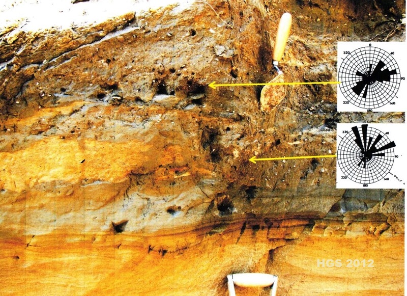
Figure
23. Danes’ Dyke west section (trowel for scale). Detail of the contact between
the glacilacustrine sediments and the overlying Skipsea Till (Diamicton 1).
4 South
Landing. Coastal cliff sections between TA 233 692 and TA 230 692.
A much wider valley
form is present at South Landing (about 230m wide, see figure 24) just 2km east
of Danes’ Dyke and sediments are exposed to both the east and west of the modern
valley.
Figure
24. South Landing valley form (cliff height is about 30m). The modern valley has
excavated the older valley fill. Note the steep Chalk cliff on the west (left)
side of the valley. The white cliff to the east (right) is composed of coarse
chalk gravels. Slumping in the upper cliff conceals thick glacigenic sediments.
To the east erratic
poor, coarse, chalk gravels are exposed and are up to 10m thick (figure 25). The
lower parts are dominantly cobble/boulder gravels, typically unorganised, though
occasionally displaying inverse grading. Bedding surfaces dips are towards the
southwest. The upper division is less coarse and has more quartz sand beds
present. In this unit bedding dips (and probably some medium sized cross beds)
suggest plaleoflows towards the north-west. This deposit is enigmatic. The
coarseness and thickness of the unit allied to the presence of probable debris
flow deposits suggest a provisional interpretation as some form of glacigenic
fan. Certainly it does not resemble periglacial deposits know from Danes’ Dyke,
Sewerby and other sites on the Yorkshire Wolds. A sample of the quartz rich
sands of the upper part of this unit has been taken for OSL dating to help place
it in the emerging chronology.
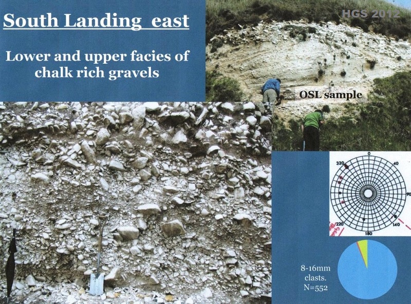
Figure
25. South Landing east section (spade and people for scale). Erratic poor,
coarse lower and finer upper Chalk gravels. Pie chart: blue=Chalk, red=flint,
green=other erratics. Is this a glacigenic fan deposit? The site of the OSL
dating sample from the upper gravels is indicated.
A very different
suite of erratic rich Chalk gravels is present to the west of the modern valley
(figure 26). Here the gravels rest on a slightly irregular Chalk platform at a
similar elevation (approximately 2.5m OD) to that beneath the Ipswichian
interglacial beach at Sewerby (Catt 2007). However, the gravels at South Landing
do not have any of the characteristics of the beach gravels at Sewerby: the
Chalk clasts at South Landing are poorly rounded, erratics make up nearly 50% of
the assemblages and no mammalian bones or marine molluscs have been found. The
gravels at South Landing are up to 3m in thickness and clast sizes fine upwards
and quartz rich sand beds become more common upwards too. A cryoturbated surface
is sometimes visible below the top of the gravels (figure 26) and frost
shattered Chalk cobbles can be seen in some of the nearby large calcreted gravel
and sand blocks on the beach in front of this section. Though field
relationships are difficult to evaluate due to slumped material at the cliff
base, the erratic rich gravels of the western exposures are believed to be
younger than the erratic poor gravels to the east. The erratic rich character of
the gravels in the western exposure, allied to the northerly palaeocurrent
directions determined from clast imbrications (figure 26) indicates these
deposits are glacifluvial outwash gravels derived from an ice margin to the
north.
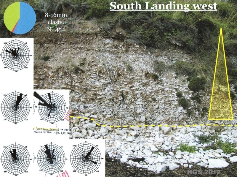
Figure
26. South Landing west section (walking pole for scale). Erratic rich Chalk
gravel on Chalk bedrock. Upper portion of the unit is cryoturbated. Glacifluvial
outwash gravel. An OSL dating sample was collected from close to the top of the
unit at an immediately adjacent section.
An hiatus in the
sequence is indicated by the periglacial surface near the top of the gravels.
Above these deposits are poorly exposed glacilacustrine facies, gravels and
sands, and finally diamictons, the whole being over 20m thick (Lamplugh 1891).
Again, the matrix colour of the diamicton, where exposed, suggests it is Skipsea
Till, though other units may be present high on the eastern cliff (Lamplugh
1891) and are the subject of further research. Samples have been taken for OSL
dating from the top of the western gravels and sands, and from the unit of
glacifluvial sand high in the western cliffs. Results are eagerly awaited!
Although Chalk
bedrock is exposed close to the modern sea level in the valleys at Danes’ Dyke
and South Landing there appears to be no preservation of beach gravels from the
last interglacial. Though the Chalk platform beneath the gravels on the west
side of South Landing may be a modified marine abrasion platform, no
interglacial marine deposits are preserved on it. Despite this, the earliest
deposits preserved within the bedrock cut valleys are significant in allowing
OSL dating which may provide a closer chronology for the advance of the North
Sea Lobe of the last ice sheet as it advanced into eastern England.
5
Acknowledgments
For help with the
ongoing research on Flamborough Head the Flamborough Quaternary Research Group
would like to thank all the members of the Hull Geological Society who have
helped with fieldwork at the sites; Mark Bateman and Dan Hartmann of Sheffield
University for the ongoing OSL dating programme; Al Gemmell and Audrey Innes of
Aberdeen University for granulometry; Lynda Howard for searching for beetles and
chironimids in samples of the rhythmites; Ian Candy of Royal Holloway University
of London for examining carbonate cements; John Catt, Colin Whiteman, John
Boardman, Julian Murton, Della Murton and Emrys Phillips for advice and
discussions.
6.
References.
Bateman M D, P C Buckland, M A
Whyte, R A Ashurst, C Boulter & E Panagiotakopolou 2011. Re-evaluation of the
Last Glacial Maximum typesite at Dimlington UK.
Boreas 40, 573-584.
Evans D J A & S A Thomson 2010.
Glacial sediments and landforms of Holderness, eastern England: a glacial
depositional model for the North Sea Lobe of the British-Irish ice sheet.
Earth Science Reviews 101, 147-189.
Eyles N, A M McCabe & D Q Bowen
1994. The stratigraphic and sedimentological significance of Late Devensian ice
sheet surging in Holderness, Yorkshire, UK.
Quaternary Science Reviews 13,
727-759.
Gibbard P L & A J Stuart 1974. Trace
fossils from proglacial lake sediments.
Boreas 3, 69-74.
Heppenstall
et al. [m.s.] 2010. Lost and found:
the pre-Skipsea Till palaeovalley fill sediments of Flamborough Head and their
significance for dating the advance of the last ice sheet in eastern England.
[Unfinished draft published on the Hull
Geological Society website in 2025.]
Lamplugh G W 1891. On the drifts of
Flamborough Head. Quarterly Journal of the
Geological Society 47, 384-431.
Penny L F & J A Catt 1967. Stone
orientation and other structural features of tills in East Yorkshire.
Geological Magazine 104, 344-360.
Rushworth G 1998. Rhythmites from
Barmston, East Yorkshire. Quaternary
Newsletter 86, 17-21.
[Notes – re-edited
2026. Some figures have not been included because of copyright issues. Some
others were not mentioned in the original text, so they have been excluded from
this new published version.]
Copyright - Hull Geological Society 2026
Registered Educational Charity No. 229147