
Humberside Geologist no 19
A Preliminary Investigation of the Layer Known as the “Head”
in the Glacial Tills of the Holderness Coast
By Graham Kings, Arthur Speed and Graham Evans,
Bisat Research Group of the Hull Geological Society.
Keywords.
Bisat
Project, Withernsea Till, Skipsea Till, Head.
Abstract.
A
preliminary investigation is reported of a layer of diamicton approximately 1
metre thick in the Withernsea Till on the Holderness Coast and described by W.
S. Bisat as a “head”. A similar layer has been observed in the Skipsea Till in
photographs taken as part of the Bisat Project, but not investigated in detail.
The “head” exhibits many properties of the adjacent layers of Withernsea Till
including particle size, colour and the clasts present, but differs in its
weathering characteristics and texture. It is concluded that the “head” has a
similar geographical origin to the Withernsea Till but differs in its deposition
process or has undergone post-deposition changes.
Introduction.
Between
April 2015 and September 2019 the authors and other members of the Hull
Geological Society, undertook the Bisat Project fieldwork, inspired by the work
of W. S. Bisat who, during 1935–1939 and 1945-1952, examined, walked and
sketched the cliffs from Easington to Sewerby (Catt and Madgett, 1981).
The HGS
Bisat Project seeks to re-examine and photograph the Holderness cliffs from
Sewerby (TA 19891 68464) to the end of the cliffs near to the Spurn Bird
Observatory (TA 30869 32454), a total of 42 miles (66 kilometres). Much of the
exposed coastal cliff comprises diamicton or till, a collective term, according
to Allaby (2013), for the group of sediments laid down by the direct action of
glacial ice without the intervention of water. During the photography project,
which involved taking sequential overlapping photographs, an unusual phenomenon
was noted comprising a 1-metre-thick recessed band of material of different
texture running almost horizontally between layers of the diamicton (Fig 1).
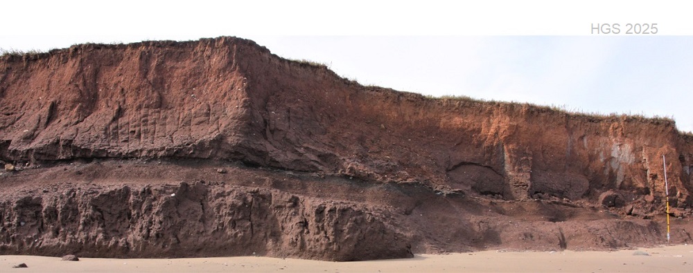
Fig 1.
The Head at location TA 36006 25596 lying here between layers of the Withernsea
Till.
While
photographing the cliffs this band was recorded as an “earthy layer”. Later it
was realised that this layer was the “head” identified by W S Bisat (1937) and
described by Bisat, Penny and Neale (1962) associated with both the Withernsea
and Skipsea Tills (formerly known as the Purple Clay and Drab Clay
respectively).
Bisat
(1937) referred to this layer as a “head”. However, this bed does not correspond
to the modern definition of a head as “a sheet of poorly sorted, angular rock
debris, mantling a hillslope and deposited by gelifluction” (Allaby, 2013; BGS
Lexicon), nevertheless this paper will continue Bisat’s use of the term “head”.
Extent of the “Head” Exposure and Location of the Site Studied.
A recent
re-examination of the Bisat Project photographs revealed other examples of this
“earthy layer” or “head” along the coast in both the Withernsea and Skipsea
Tills. These exposures are listed in Table 1 and the coastal areas involved
shown in Fig 2. It should be noted
that because of coastal erosion, typically 2m/year, the grid references reflect
locations when the cliffs were photographed and are now off the current
coastline.
|
AREA OF
THE COAST |
OS MAP
GRID LOCATION
TA |
|
Withow Gap to
Hornsea |
18504 54272 |
|
|
18811 53389 |
|
|
18886 53180 |
|
|
19002 52869 |
|
|
19041 52758 |
|
Hornsea to
Mappleton |
21215 46776
to 21375 46410 |
|
|
21866 45457 |
|
|
21906 45395 |
|
|
21995 45253 |
|
|
22010 45229 |
|
|
22142 45015 |
|
|
22099 45053 |
|
|
22307 44747 |
|
Mappleton to
Aldbrough |
23278 43021
to 23339 42928 |
|
|
23444 42749 |
|
|
24138 41725 |
|
Aldbrough to
Tunstall |
29224 34572
to 29277 34501 |
|
|
29438 34283
to 29493 34211 |
|
|
29960 33578 |
|
|
30000 33531 |
|
|
30636 32737 |
|
|
30869 32454 |
|
Tunstall to
Withernsea |
31533 31582 |
|
|
32645 30102 |
|
|
32720 30005 |
|
|
32971 29716 |
|
Withernsea to
Easington |
35074 26768
to 35652 26049 |
|
|
35737 25948
to 35771 25901 |
|
|
35801 25859
to 35927 25697 |
|
|
35994 25609
to 36225 25326 |
|
|
36291 25248 |
|
|
36305 25230 |
|
|
37254 24012 |
|
|
37309 23953 |
|
|
37449 23798 |
|
|
37480 23758 |
[Table
1. Exposures of the “head” noted in the field during the Bisat Project
and subsequently during examination of
the photographs.]
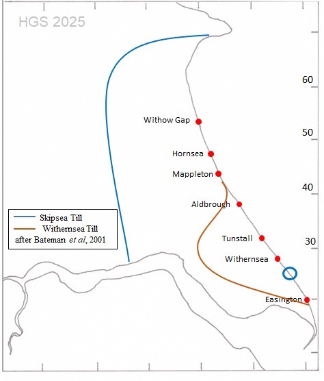
[Fig 2. Coastal Areas where the “head” was visible in Bisat Project photographs.
Towns correspond to those listed in Table 1.
Circle
O shows approximate location shown in Fig 1 and site studied (Fig 3).]
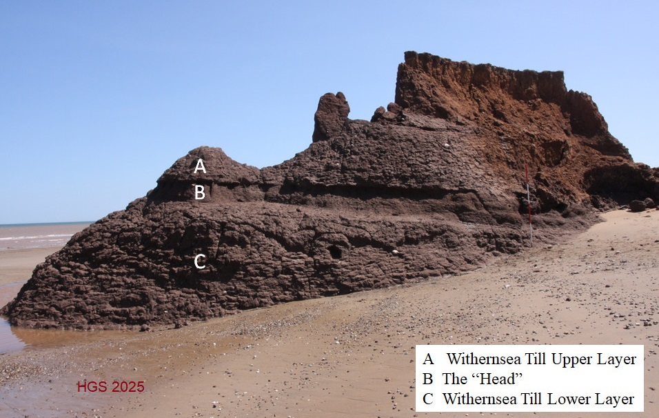
[Fig 3.
The section studied at TA 35816 25746 showing the “Head” and the Upper and
Lower Layers of the Withernsea Till.]
Field
Observations .
The
lithology of the site is shown in Fig 3. The ”head”, a diamicton, lies between
two diamicton layers constituting the Withernsea Till which for the purpose of
this paper we have called the Upper Layer and Lower Layer. The Upper Layer is
divided by a gravel layer and lies below a sand bed and soil. As is common on
the East Coast, the site is being rapidly eroded by the sea and had formed a
promontory allowing both sides to be examined.
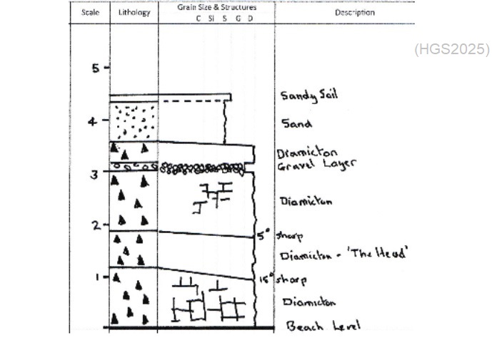
[Fig
4. Field lithology log of section at TA 35816 25746].
As shown
in Fig 4, the surfaces of the Upper and Lower Layers show vertical and
horizontal weathering patterns while the weathered surface of the “head”
resembles horizontal laminations. The surface of the “head” is eroded
approximately 10cm more than the Upper and Lower Layers causing it to be
recessed.
Samples
from cleaned surfaces were compared with Munsell Charts and the results recorded
and presented in Table 2 together with the maximum size of clasts, the response
to a magnet and the reaction to 10% hydrochloric acid.
|
EXAMINATION |
UPPER LAYER |
HEAD |
LOWER LAYER |
|
Tactile
Properties |
Moulds like putty |
Crumbles easily |
Moulds like putty |
|
Max size of
clasts |
Up to 13 mm |
Up to 10 mm |
Up to 15 mm |
|
Reaction to
magnet |
None |
None |
None |
|
Reaction to H CL |
Strong fizz |
Strong fizz |
Strong fizz |
|
Munsell colour |
5YR 3/2 |
5YR 3/2 |
5YR 3/2 |
|
Strain vane
Kg/cm2 |
All readings >1
Kg/cm2 |
All readings>
1Kg/cm2 |
All readings
1Kg/cm2* |
[Table
2. Field examination of the Tills.]
An
attempt was made to measure the rheological characteristics of the tills using a
strain vane gauge on both the north and south sides of the promontory. However,
all readings were at or above the limit of the strain vane scale i.e. 1Kg/ cm2
(see Table 2).
Using
the hand-held bulb planter described below a sample was taken from each layer
and pushed out onto the beach (Fig 5). The texture of the core taken from the
“head” was noticeably different from that taken from the Upper and Lower Layers.
The cores of the Upper and Lower Layers were noted to be of a firm and moist
consistency which could be moulded in the hands like putty. The “head” layer
crumbled in the hand.
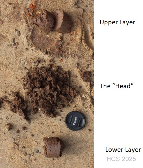
[Fig 5.
Samples of tills taken with a bulb planter and pushed out onto the sand.]
Offsite Examination of Samples.
Collection of Samples.
Using a
bulb planter corer, manufactured by Burgon and Ball of Sheffield, 6 cm in
diameter and 16 cm long, further samples of the “head “and Upper and Lower
Layers were taken for off-site examination. Difficulty was experienced when
taking the sample from the Upper Layer because the same amount of force could
not be exerted when reaching up. The
“head”, being softer and more friable, was easier to sample as was the easily
reached Lower Layer. Therefore the same quantity of sample could not be obtained
from each layer (see Table 3). The bulb planter was cleaned between each
sampling to prevent contamination. The samples were placed in clean polythene
bags and labelled.
Preparation of Samples.
On
return from the field the samples were weighed and gently disaggregated using a
pestle and mortar. They were then allowed to air dry before the dry weight of
each specimen was recorded.
The
sample was de-flocculated by boiling with a dilute aqueous solution of washing
soda for 30 minutes and then wet sieved using a larger than 2.0mm sieve to
remove large clasts followed by 125µm and 63µm sieves. The residual fractions of
the samples were then air dried again and reweighed (Table 3). Each residue
sample was stored in labelled test tubes.
In
addition the 125µm to 2mm sample was dry sieved using a 500µm sieve in
preparation for microscopic examination of the clasts. Reflecting the initial
sample weights the dry sieving provided a 2.0g sample of the Upper Layer, a 4.0g
sample of the “head” and a 5.0g sample of the Lower Layer.
|
SAMPLE |
UPPER LAYER |
HEAD |
LOWER LAYER |
|
Total wet weight |
98g |
161g |
228g |
|
Total dry weight |
92g |
150g |
210g |
|
> 2.00 mm |
9.0g (9.8%) |
15.0g (10%) |
14.0g (6.7%) |
|
125µm-2.0 mm |
12.0g (13%) |
22.0g (14.7) |
26.0g (12.3%) |
|
63µm-125µm |
10.0g (10.9%) |
17.0g (11.3%) |
21.0g (10%) |
|
Clay and Silt |
61g (66.3%) |
96g (64%) |
149g (71%) |
[Table
3. Specimen weights and grain size distribution.]
Microscopic Examination of the Clasts.
The
500µm to 2mm sieve fraction samples of each layer were microscopically examined.
It was found that the clasts in the
samples could be classified, based on their colour and lustre, to one of eight
different clast types as shown in the first column of Table 4.
This finding was confirmed by
experimental trial assessments across the layers and “head”.
The
number of clasts of each clast type was determined by a team of two. One
examined the sample scattered over a sampling tray using a x10 binocular
microscope and verbally assigned each clast to a colour and lustre clast type.
The second team member recorded the classification on a printed form which
listed the eight clast types (Table 4). This method permitted the recording of
many clasts in a relatively brief period before fatigue affected the observer.
Approximately 1000 clasts were classified per sample.
Subsequently representative examples of the eight clast types were examined by
Mike Horne, Secretary of the Hull Geological Society, who identified their
mineralogy which is recorded in the second column of Table 4.
|
DESCRIPTION OF THE CLAST
(Colour &
Lustre) |
MINERALOGY
OF THE CLAST |
UPPER
LAYER |
HEAD |
LOWER
LAYER |
|
Granular
grey/white |
Quartz mica
rock |
100 (9.54%)
|
132 (11.96%) |
89 (11.1%) |
|
Black Shiny |
Coal |
58 (5.53%)
|
66 (5.98%) |
94 (8.4%) |
|
Dull Grey |
Coal or
igneous rock |
319 (30.43%)
|
262 (23.75%) |
379 (33.9%) |
|
Sparkly Grey
|
Grey
sandstone |
21 (2.0%)
|
85 (7.7%) |
80 (7.2%) |
|
Brown |
Sandstone or
red mud rock |
96 (9.16%)
|
133 (12.05%) |
32 (2.9%) |
|
Red |
Red sandstone
or red quartz |
5 (0.47%) |
11 (0.99%) |
19 (1.7%) |
|
White
Translucent |
Quartz |
394 (37.6%)
|
323 (29.28%) |
323 (28.9%) |
|
White Opaque |
Chalk |
50 (4.77%) |
83 (7.52%) |
91 (8.1%) |
|
Miscellaneous |
Unidentified |
5 (0.47%) |
7 (0.6%) |
8 (0.7%) |
|
Fossil |
|
0 |
1 (0.09%) |
2 (0.18%) |
|
Total Clasts |
|
1048 |
1103 |
1117 |
[Table
4. Microscopic examination of clasts.]
Fig 6
shows the proportion of each clast type in terms of its mineralogy for the Upper
Layer, Lower Layer and “head”. It was found difficult for some of the grey rocks
to assign them with certainty to a particular clast type. Therefore, the counts
for the Granular / Grey White, Dull Grey and Sparkly Grey (Quartz mica rock,
Coal or igneous rock and Grey sandstone respectively) were combined in Fig 6
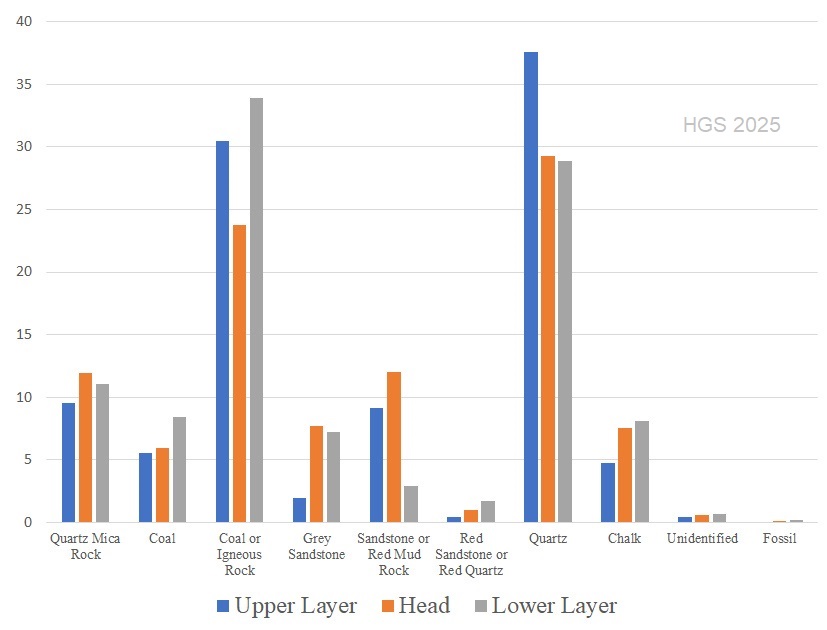
[Fig 6.
Percentage of clasts in the Upper Layer, Lower Layer and “head”.]
Discussion
Determining the extent of a layer, such as the “head” in coastal cliffs is
frustrated by the presence of slumping, vegetation, changes of elevation with
respect to beach level and man-made interventions such as sea defences and war
time installations. With this in mind, field notes made during the Bisat Project
and subsequent examination of the photographs suggest that the “head” may be a
near continuous layer south of Withernsea to Holmpton in the Withernsea Till and
also present in the Skipsea Till as was found by Bisat, Penny and Neale (1962).
Observations on the site, south of Withernsea, show the “head” and the Upper and
Lower Layers of Withernsea Till have similar Munsell Colour, reaction to HCl,
magnetic properties and maximum size of clast (Table 2). Sieved harvested
samples of each of the three layers also show a similar percentage weight
fraction of material retained on 2.00 mm, 125µm, 63µm sieves and in the
clay/silt (<63µm) fraction (Table 3).
Recognising the limited resources available to the authors, microscopic
examination of the 500µm sieve fraction suggests a similar percentage of clasts
by number, classified according to colour and lustre (Fig 6) in the Lower and
Upper Layers and “head”.
Erratics
in tills are characteristic of their geographic source (Evans and Benn, 2014).
Thus the above observations support a hypothesis that the material responsible
for the “head”, has a similar geographical origin as the Upper and Lower Layers
of the Withernsea Till found south of Withernsea. The Withernsea Till originated
from Lake District ice before crossing the Pennines via the Stainmore Gap and
overriding Skipsea Till ice from south-east Scotland and north-east England
(Catt, 2007).
The
“head” differs from the Upper and Lower Layers of the Withernsea Till in a
number of ways:
·
In-situ
the “head” is weathered back relative to the surfaces of the Upper and Lower
Layers.
·
The
“head” weathers to a pattern resembling horizontal laminations while the Upper
and Lower Layers exhibit horizontal and vertical cracking.
·
The
“head” crumbles easily whereas the Upper and Lower Layers mould like putty in
the hand.
The
observation that the difference in appearance was due to surface weathering was
made by Rodger Connell (Connell, 2023 pers. cor.) while reviewing photographs
taken as part of the Bisat Project. He noticed that when material fell away from
the junction of the “head” and till, the head is no longer clearly defined; it
needs surface weathering for the difference in the beds to become clearly
visible.
The
distinctly different properties described above, are not unusual for tills with
the same composition since in addition to the gravitational forces during
deposition they are subject to differing amounts of shear (Clark, 2018).
The
observation that the “head” has been seen in both the Withernsea and Skipsea
Tills supports the view that the process responsible for their formation
occurred at the site of deposition.
Mention
has been made that the term “head” was used by Bisat, but that the bed
investigated would not meet the modern definition of that term. It is
interesting to speculate why Bisat used that term, other than it was at the top
of a bed. Equally it could be that he was alluding to the process of deposition.
Conclusions.
This
study has begun to explore a band of diamicton described by Bisat as “head”
located south of Withernsea in the Withernsea Till. It is found that the “head”
exhibits many properties of the adjacent layers of Withernsea Till including
particle size, colour and clasts present but differs in its weathering
characteristics and texture. It is concluded that the “head” has a similar
geographical origin to the Withernsea Till but differs in its deposition process
or has undergone post-deposition changes.
A band
of diamicton with similar appearance was also been found in the Skipsea Till
during the photographic Bisat Project.
The
“head” exhibits different weathering patterns and texture to the surrounding
till and further work is required both in the Withernsea and Skipsea Tills at
other locations to explore these differences further. In particular it is
believed that the use of a stronger shear vane might be informative. Further
research is required to understand how different deposition processes and
post-deposition environments influence the properties of tills.
Acknowledgements.
Mike
Horne, Dennis Haughey and Roger Connell, other members of the Bisat Project.
References.
Allaby M
(ed) 2013. A dictionary of geology and earth sciences. Oxford University
Press, USA.
Bisat W
S 1937. Reports of Field Meetings for 1936 (Hornsea). Proceedings of the
Yorkshire Geological Society 23, 125-7, pl. vi.
Bisat W
S, L F Penny & J W Neale 1962. Geology around the University Towns: Hull.
Geologists’ Association Guides 11, 1-34.
British
Geological Society [accessed 24 March 2025].The BGS Lexicon of Named Rock
Units – Head. Available at:
Catt J A
2007. The Pleistocene glaciations of eastern Yorkshire: a review. Proceedings
of the Yorkshire Geological Society 56(3), 177-207.
Catt J A
& P A Madgett 1981. The Work of W. S. Bisat FRS. Chapter 12, pp 119-136 of Neale
& Flenley (eds) The Quaternary in Britain: Essays, Reviews and Original Work
on the Quaternary Published in Honour of Lewis Penny on His Retirement,
Pergamon Press.
Evans D
J & D I Benn (eds) 2004. A practical guide to the study of glacial sediments.
Routledge. 290pp.
copyright Hull Geological Society 2025