Humberside Geologist no. 16
Was Rifle Butts SSSI ever a Quarry, and who used it?
By Mike Horne FGS
Rifle Butts SSSI is a small geological exposure near
Goodmanham, East Yorkshire. It was designated as a SSSI in 1952 and was
purchased as a nature reserve by the Yorkshire Naturalists’ Trust (now the
Yorkshire Wildlife Trust) in 1964. In
1987 the Hull Geological Society agreed to adopt the exposure and keep it tidy
(Horne & Dutton 1999). A protective shelter was added in 1994 (Beveridge 1994,
Horne 2007).
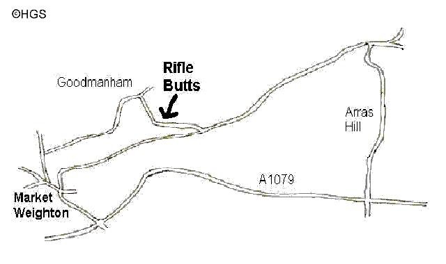
There is no rifle range or railway shown on the 1850s
Ordnance Survey map
The site was widely believed to have been a quarry opened
to provide material for the nearby railway embankment (Scaife
et al. 1995, Horne & Dutton 1999,
Yorkshire Wildlife Trust website) but it seems to be too tiny to have produced
any significant amount of material.
The act of Parliament enabling the railway to be built
from Market Weighton to Beverley was approved 1862. The single track line opened
in 1865 (Wikipedia) and was upgraded to double track in 1889 (The Rambling
Walker 2003). The last train ran on the line in 1965 and it was converted into
the Hudson Way trail in 1983 (The Rambling Walker 2003).
The Ordnance Survey map for the 1890s shows a rifle range
firing 600 yards from west to east on the northern side of Spring Dale, from the
Scrogs woodland towards Springs Plantation. There is a flagstaff shown
presumably to fly a warning flag but no earthworks within the target area.
The maps for the 1900s and 1910s show the rifle range in
its present position on the south side of Spring Dale, shooting along a field
previously known as Toad Holes, west to east for 800 yards. There are earthworks
every 100 yards in the field, and, on the other side of the road the butts are
shown in their present position. A flagstaff is shown on the western side of
Snever Dale, just above the 250ft contour. There are also some earthworks in the
field to the east of the site heading towards Springs Plantation: were these
also part of the rifle range?

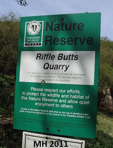
In 1942 Ted & Willy Wright called the site Rifle Butts Pit. The rifle range is shown as disused on the 1950s map and there is no flagpole marked. Lewis Penny (1958) refers to the site simply as “the Rifle Butts near Goodmanham” and notes that the “sections becomes quickly obscured but a little digging reveals an ascending succession…”. In the Annual Report of the Yorkshire Geological Society for 1963 it is recorded that
“proposals by Council, originally made in 1960, for the preservation of the Rifle Butts Quarry section at Goodmanham, Market Weighton, have been implemented during the year”. It is not until the 1970s that the geological site is named as Rifle Butts Quarry on the OS map.
If you visit the area today, you will see a sturdy
concrete gatepost on the road just up from the dismantled railway bridge and a
sturdy wooden one at the Goodmanham end of the road; are these the sites of
gates that were used to close the road when the range was in use? In the nature
reserve you can make out a steep gravel bank at the eastern end which presumably
caught any stray bullets. There is an embankment in the middle of the site with
a few trees growing on it and lush vegetation growing in the infilled target
pit. To the west of the reserve the area is flatter than the adjoining field and
slightly raised in comparison. Across the road along Spring Dale the embankments
built for the range can still be seen, though some are overgrown.
Attempts have been made by Mike Horne and Rod Towse to
establish who used the rifle range and when. We have not found any military
records that mention a rifle range at Goodmanham. There are some records of the
9th Market Weighton Rifle Volunteer Corps being formed in 1860, which
then became part of the 5th Cyclist Battalion of the East Yorkshire
Regiment, a Territorial Force from 1908 to 1920 (Wikipedia).
Horne and Dutton (1999), using information obtained from
the YWT warden, state that the site “was later bought by a local farmer who
rented it to the local rifle club until the 1940s”.
Although small outcrops of the Red Chalk were known in the Goodmanham area in Victorian times there do not seem to be any mentions of the Rifle Range in geological publications until the 20th century. On 4th November 1904 members of the Yorkshire Geological Society led by P F Kendall or J W Stather visited “the shooting range at Goddmanham… ” and observed the Red Chalk “and in the pit below, Lower Lias” (anon 1905). Tom Sheppard records that traces of the Lias could be seen in the target pits at the site (anon 1918). Kendall and Wroot (1927) mention the Rifle Butts and the geological significance of the site but do not call it a quarry. Wright and Wright (1942) state that the site was becoming overgrown.
The Yorkshire Wildlife Trust’s website states that the
rifle range was in
use from the 1890s until World War I and Scaife
et al. (1995) suggest it was used from
the start of the Boer War in 1899 until the end of World War I. The Market
WeightonTown
Council website says it was used up until World War II. The Goodmanham Parish Council website states that it was
used in the 1930s and 1940s by the Home Guard.
Ian Richardson (2019) states that it was used during World War II by the
Home Guard for firing practice.
Interpretation –
It would seem that the present Rifle
Butts SSSI was created for the Rifle Range after the railway was constructed.
Chalk gravels washed down from Snever Dale at the east of the site were
excavated and perhaps used to level the ground to the west.

Acknowledgements –
I thank Paul Hildreth for providing
additional information at the editing stage of this article.
References-
Anon 1905. Record of meetings.
Beveridge D 1994. A shelter for Rifle Butts.
Earth Heritage 2, 31
Goodmanham Parish Council Official Website (accessed
2020).
http://www.goodmanhamparishcouncil.co.uk/local-walks.aspx
Horne M in Stanley M 2007. Are we really conserving sites
for the distant future?"
Earth Heritage
28. 22-23
Kendall PF & H E Wroot 1927.
The Geology of Yorkshire. (page 807)
Market Weighton Town Council (web site accessed 2020).
http://www.marketweightontowncouncil.gov.uk/local-attractions.aspx
Ordnance Survey (accessed 2020). Digimap Historic Roam
maps available via Edina.
Penny LF 1958. Cretaceous stratigraphy. p178 of De Boer
G, J W Neale and L F Penny. A guide to the geology of the area between Market
Weighton and the Humber. Proceedings of
the Yorkshire Geological Society 31, 157-209.
Richardson I 2019.
May the faith go with you at Goodmanham.
Just Beverley, issue 52,
31
G Scaife, M Horne, D Beveridge,
et al. 1995 Rifle Butts Quarry. Yorkshire Wildlife Trust information
leaflet.
Wikipedia (accessed 2020). 5th
(Cyclist) Battalion, East Yorkshire Regiment
https://en.wikipedia.org/wiki/5th_(Cyclist)_Battalion,_East_Yorkshire_Regiment#Territorial_Force
Wikipedia (accessed 2020). York-Beverley Line.
https://en.wikipedia.org/wiki/York%E2%80%93Beverley_line
Wright EV & CW Wright 1942. The Chalk of the Yorkshire
Wolds. Proceedings for the Geologists’ Association 53, 112-127
Yorkshire Wildlife Trust (accessed 2020). Rifle Butts
Quarry Nature Reserve
https://www.ywt.org.uk/nature-reserves/rifle-butts-quarry-nature-reserve
copyright Hull Geological Society 2020