Geological fieldwork techniques
tutor: Mike Horne FGS
for the Centre for Life Long Learning
This course ran in Summer 2002, Summer 2005, Summer 2008 and Summer 2011
Far too often we rely on our memory of sites or regret that we did not gather the right information. This practical course will teach us to be more methodical and thorough in our approach to fieldwork and site recording.
The content of the course included -:
Field work safety
Risk assessments
Some map reading (if required)
Site conservation and the ethics of collecting
Principles of stratigraphy
Recording observations in the field
Measuring dip and strike
Measuring and recording stratigraphy
Drawing a 'graphic log'
Sampling techniques
Recording Till fabrics and clast orientation (perhaps)
Geological mapping
Drawing a final geological map
Writing a scientific report about the area mapped
Sources of old data - publications and maps
There is a certain degree of flexibility in the course and the choice of fieldwork venues. The students will carry out the fieldwork in groups and encouraged to co-operate in the production of the reports of the fieldwork. Students will be asked to record their fieldwork (notebooks, logging sheets and field mapping slips) and present their measurements and observations in a scientific report, for assessment. They may prefer to present their work to the class or tutor, or present evidence of their learning to the tutor in some other (mutually agreed) way, such as a display of specimens collected and graphic logs.
The course will involve fieldwork. Students will be expected to provide their own outdoor clothing. Hard hat will be provided. The tutor reserves the right to ban students not suitably dressed for the conditions or who behave in a dangerous way. The fieldwork will be carried out at weekends, after some initial classes in the laboratory, consisting of illustrated talks and discussions. The dates of the fieldwork will be arranged once the class has started and may depend on suitable tides. Students will be asked to share lifts to and from the fieldwork.
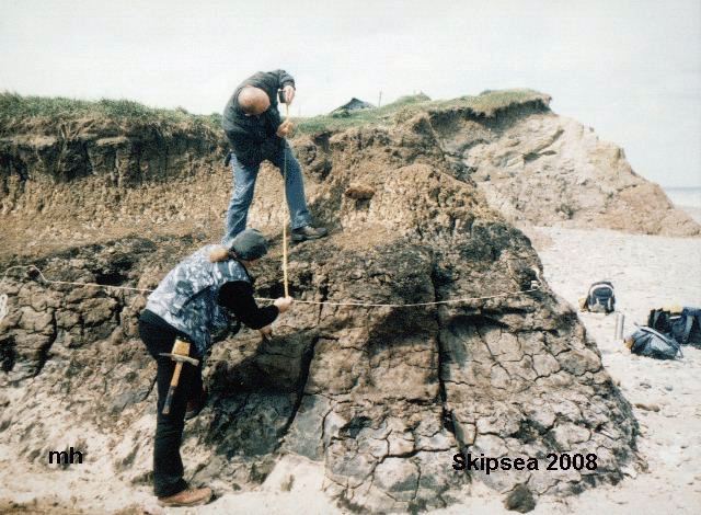
Fieldwork - there are various places that we can visit for our 3 half day field trips. Most of these will depend on the tide - so please bring your diary to the first meeting so that we can arrange the dates to suit the majority of people.
There are four sites that we use for fieldwork - Filey Brigg, Skipsea Withow, Newbald village and the Holderness Coast.
Recommended reading
Barnes J W & R J Lisle 2004. Basic Geological Mapping (4th edn). John Wiley & Sons, Chichester. isbn 0-470-84986-X. 184pp.
Woodcock N 1994. Geology and environment in Britain and Ireland. UCL Press, London. isbn 1-85728-054-7.
Course Links -
The Geological Code
Local geology
Collecting Rocks, Minerals and Fossils in East Yorkshire by Ros Perry
Lithostratigraphy of East Yorkshire
Holderness Geology by Tracy Marsters
Pebbles on the Holderness beaches by Mike Horne
Data for and from the Course Fieldwork
Generalised stratigraphy of Filey Brig
Generalised Geology of the Newbald area
Skipsea Withow logging data
Skipsea Withow Mere report by Tracy Marsters
Course achievements and conclusions

copyright Mike Horne - 2019
Hull Geological Society Home Page Geology Courses Homepage