
Humberside Geologist no. 15
Quaternary Geology of the Holderness Coast:
A Brief Overview
Tracy J. Marsters
Introduction
The Quaternary Period is comprised of the Pleistocene and Holocene Epochs, which make up approximately the last 2.6 million years of Earth’s history. Due to its frequent cold nature, it is often termed the ‘Ice Age’. However, during the Quaternary ‘Ice Age’, temperatures were not permanently cold, but rather went through cycles of cold (glacial) periods interspersed by rather shorter and warmer (interglacial) periods. Again, both glacial and interglacial periods show fluctuations in temperature. A glacial event marked by a warm period that is either short or of not sufficiently high temperature to be classed as an interglacial, is termed an interstadial (Cox & Moore, 1998). The cold part of the cycle being termed a stadial. These marked fluctuations in climate during the Quaternary are now well documented in the records from deep ocean cores and the surviving Greenland and Antarctic ice sheets. The cold and warm periods are termed Marine Isotope Stages (MIS) and are numbered back in time from the present warm period (the Holocene, MIS 1) (see Table 1 below) (Wilson, Drury and Chapman, 2000). ‘Marine Isotope Stages’ are derived by measuring the ratio of two oxygen isotopes, termed O16 and O18, found in foraminifera skeletons preserved in deep sea sediments (Stanley, 1993). The ratio differs depending on the amount of ocean water stored in glacial ice. Sea water has a higher O18:O16 ratio than glacial ice because water containing the lighter O16 isotope evaporates more easily than water containing the heavier O18 isotope (Wicander, 1993). Thus, as glaciers expand and temperatures fall, the ratio of O18:O16 increases in seawater and as a consequence also in the foraminifera skeletons (Stanley, 1993).
What the ice sheets left behind
All sediments that are deposited in glacial environments are known as ‘drift’, a term coined when all of the deposits were thought to have been left by drifting icebergs (Skinner et al., 2004). Modern geological maps now term them ‘superficial deposits’ to differentiate them from the hard bedrock (such as the Chalk of the Wolds). There are two main types of drift: stratified and unstratified. Boulder clay, or till, is non-sorted, unstratified drift that is deposited directly by glacial ice (Skinner et al., 2004). This is comprised of a random mixture of rock fragments, embedded in a fine-grained matrix. The matrix is derived from the base of the glacier eroding the land over which it is passing, and from reworking of pre-existing fine-grained sediments (Skinner et al., 2004). Rock fragments that are different from the underlying bedrock are called erratics and are used to help trace the flow path that the glacier had travelled. Till deposits makes up the majority of Holderness cliffs and can be seen along most of the coastline.
Stratified drift is not deposited directly by glacial ice but by meltwater flowing from the ice. Depending on the turbulence of the meltwater, these deposits can range from coarse sands and gravels, to fine-grained silts and clays (Skinner et al., 2004). Turbulent streams heavily loaded with sediment, deposit coarse sands and gravels, forming layers of stratified material known as outwash (Wicander & Monroe, 1993). Sometimes meltwater issuing from a glacier may become ponded to form lakes. Glacial lakes usually accumulate finely laminated muds consisting of alternating bands of coarse and fine-grained sediments (Stanley, 1993). Each pair of layers, one varve, represents one year’s deposition (Wicander & Monroe, 1993). The coarser, lighter coloured layer of the varve forms during the summer months when sediment from meltwater streams is carried into the lake (Stanley, 1993). During the winter, the lake surface freezes and fine-grained, darker coloured clays and organic matter settle from suspension (Wicander & Monroe, 1993). Layered gravels and sands, and varves can be seen along the coast, for example at Skipsea Withow Mere and Barmston (Varley, 1968; Gilbertson et al., 1987). Meres, of which there were formerly many in Holderness, formed upon glacial retreat and are the product of standing water rapidly accumulating in poorly drained, low-lying areas or in kettle holes (holes formed where blocks of ice that remained after glacial retreat finally melted) (Flenley, 1987; Gilbertson, 1990).
The glacial tills of Holderness, their associated deposits, and chronology
Before the last ‘Ice Age’ the area in Yorkshire from Flamborough Head to the Humber formed a large bay. The old coastline followed the eastern side of the present day Yorkshire Wolds, and would have stretched from Sewerby to Hessle (Figure 1) (Lamplugh, 1887; Walton, 1894; Catt, 2001b). The Wolds are composed of Chalk from the Cretaceous Period. During the last ice sheet advance, glacial deposits filled this bay, forming the area now known as Holderness. Yorkshire and North Lincolnshire possibly show evidence of three glacial advances during the Quaternary: the Anglian ice sheet advance of about 450,000 years ago, the "Wolstonian" *’ ice advance possibly of about 140,000 years ago, and the most recent Devensian glacial advance between 18,000 to 13,000 radiocarbon (14C) years BP (approximately 23,000 to 15,000 calendar years BP) (see Table 1) (Penny et al., 1969; Beckett, 1981; Catt, 1990; Gearey & Liley, 2001; Catt, 2007).
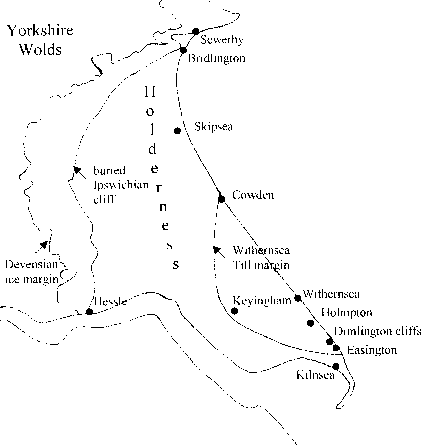
Figure 1. Holderness, showing the approximate positions of the buried Ipswichian cliff, the Devensian ice margin, and the margin of the Withernsea Till. Locations refer to those mentioned in the text (adapted from Catt, 2007).
Table 1. Middle Pleistocene to Holocene geological timescales.
|
Period |
Stage |
Date (14C years BP) |
Yorkshire climate |
Local deposits |
|
|
Holocene |
Flandrian (MIS 1) |
10,000- present |
Temperate |
Mere deposits |
|
|
Late Pleistocene |
Devensian (MIS 2–5d) |
Late |
26,000-10,000 |
cold |
Withernsea & Skipsea Tills; Loess; Dimlington silts |
|
Middle |
50,000-26,000 |
||||
|
Early |
117,000-50,000 |
||||
|
Ipswichian Interglacial (MIS 5e) |
128,000-117,000 |
Warmer than present |
Sewerby beach |
||
|
Middle Pleistocene |
Wolstonian |
Cold episode (MIS 6) |
350,000-128,000 |
Cold |
Possible deposition of Basement Till |
|
Interglacial (MIS 7) |
Warm |
||||
|
Cold episode (MIS 8) |
Cold |
||||
|
Interglacial (MIS 9) |
Warm |
||||
|
Cold episode (MIS 10) |
Cold |
||||
|
Hoxnian Interglacial (MIS 11) |
430,000-350,000 |
warm |
|||
|
Anglian glaciation (MIS 12) |
480,000-430,000 |
Cold. Yorkshire possibly fully glaciated |
|||
Adapted from Penny, 1974; Catt, 1987a; Catt, 2007; Ensom, 2009.
In Holderness there are three distinct tills. These are the Basement, Skipsea and Withernsea Tills, all three of which can be seen in the cliffs at Dimlington (Figure 1) (Madgett & Catt, 1978; Catt, 2001a). The once quoted Hessle Till is now known to be a post-glacial weathering profile developed on the Withernsea and Skipsea Tills (Madgett, 1975; Madgett & Catt, 1978). The total thickness of the tills is up to 80 metres thick at the coast, but thins towards the edge of the Wolds. One of the most useful distinguishing features of the three tills is their matrix colour (Catt & Penny, 1966; Madgett & Catt, 1978). The Basement Till is dark grey to olive grey, the Skipsea Till is a very dark greyish brown, and the Withernsea Till is dark brown in colour (Madgett & Catt, 1978). Other distinguishing features include their particle size distribution, carbonate content, mineralogy, and the type of erratics contained within them (Catt & Penny 1966; Madgett & Catt, 1978).
The ‘Wolstonian’ Basement Till
The lowest of the three tills, the Basement Till, can be seen low in the cliffs between Holmpton and Kilnsea, and very rarely between Bridlington and Sewerby (see Figure 1) (Lamplugh, 1884; De Boer et al., 1965; Catt & Penny, 1966). As far as is known, this is the oldest till in Holderness, and is thought to be the product of a ‘Wolstonian’ glacial advance, possibly during MIS 6 immediately before the Ipswichian interglacial, though it may be older (see Table 1) (Catt & Penny, 1966; Catt & Digby, 1988; Catt, 2007). Although several authors have suggested the Basement Till is Late Devensian in age (Eyles et al., 1994; Lewis, 1999), Catt (2007) suggests the data is insufficient to reject the current stratigraphic model. Its patchy occurrence along the coast is thought to be the result of Ipswichian erosion (Catt, 1987a). The Basement Till has been shown to extend downwards almost to the chalk bedrock (Lamplugh, 1919 in Catt & Digby, 1988; Catt & Digby, 1988). The absence of Anglian age deposits (in areas so far surveyed) is thought to be due to marine erosion, and as such, any pre-‘Wolstonian’ tills would most likely occur where the bedrock surface is deeper than the ‘Wolstonian’ marine erosion surface (Catt & Digby, 1988). The erratics contained within the clay matrix show that the Basement Till is almost entirely derived from northern British sources with material of Scandinavian origin also present (Catt, 1991; Catt, 2007).
Along the coast at Dimlington and Bridlington (see Figure 1) the Basement Till can be seen to contain both small and large inclusions, or ‘rafts’, of bluish-grey richly fossiliferous clay and sand called the Bridlington Crag (Lamplugh 1881a, 1881b, 1884; Bisat, 1939; De Boer et al., 1965; Catt & Penny, 1966). These rafts are extremely rich in both micro and macrofossils (see Catt & Penny, 1966; Catt, 1987b). Microfaunal evidence suggests they are fragments of marine sediment that were deposited under cold conditions (Catt & Penny, 1966), and are thought to have been torn from the floor of the North Sea during the advance of the glacier that deposited the Basement Till (Lamplugh, 1884; Catt & Penny, 1966).
The Ipswichian Interglacial beach at Sewerby
At Sewerby, beach sediments that are associated with an ancient cliff cut into the chalk bedrock have been shown to overly the Basement Till. This cliff, in turn, is buried beneath the Skipsea Till (Catt & Penny, 1966; Catt 2001b). Using fossil evidence, including the bones of hippopotamus, this beach has been dated to the Ipswichian Interglacial stage (MIS 5e) (see Table 1) (Catt & Penny, 1966; Boylan, 1967). A date within the Ipswichian has also been confirmed by luminescence dating of associated sands (120,840 ± 11,800 years BP), thus implying the Basement Till must be the result of pre-Devensian glaciation (Bateman & Catt, 1996). Although the beach is exposed at Sewerby, it is believed to extend beneath the Skipsea Till continuously along the eastern side of the Yorkshire Wolds (Catt & Penny, 1966; Catt 2001b). It was formerly seen again at Hessle where it intersects the north bank of the Humber (Walton, 1894; Catt, 1990). The fossils obtained from Hessle differ from those at Sewerby, implying colder conditions than the Ipswichian Interglacial. However, these were recovered from deposits younger than the beach and are thus probably Devensian in age (Boylan, 1967).
The Dimlington Silts of the Late Devensian
Along the cliffs at Dimlington, laminated deposits of sands and silts occupy a series of basins in the surface of the Basement Till, which are in turn overlain by the Skipsea Till (Bisat & Dell, 1941; Catt & Penny, 1966; Catt, 2001a). These sediments are thought to have been deposited in a single freshwater lake, in a period just prior to advancement of the glacier which deposited the overlying Skipsea Till (Catt, 1987a). However, these deposits are not horizontal, but deformed parallel to the underlying surface of the Basement Till (Catt, 2001a; Catt, 2007). It is thought that the incoming Skipsea Till glacier caused disturbance and folding of the upper Basement Till (Penny & Catt, 1967), resulting in the series of basins now seen (Catt & Penny, 1966; Catt, 2001a). Moss from basal deposits of the basins has been dated to 18,240 ± 250 and 18,500 ± 400 radiocarbon (14C) years BP (approximately 21,000 to 23,000 calendar years BP) (Penny et al., 1969; Catt, 2007). This, along with examination of insect remains, suggest the Late Devensian glacier was close by, and may have reached Dimlington soon after 18,240 14C years BP (Penny et al., 1969; Catt, 2001a).
Prior to the arrival of the Late Devensian glacier, a thin layer of loess (wind blown silt 1/16 – 1/32 mm in diameter) was deposited over much of the area (Catt et al., 1974). At the same time exposed surfaces of the chalk was affected by frost leaving a layer of frost shattered chalk and flint (Catt et al., 1974). A thermoluminescence date of 17,500 ± 1,600 years BP has been obtained from this loess deposit at Eppleworth quarry, near Hull (Wintle & Catt, 1985) suggesting the ice advance may actually have been significantly younger.
The Late Devensian Skipsea and Withernsea Tills
The remaining two tills are the Skipsea Till (previously called Drab Clay) and the Withernsea Till (previously called Purple Clay), named after towns on the Holderness coast where the cliffs expose only one till (Madgett & Catt, 1978). The Skipsea Till extends throughout Holderness, with the Withernsea Till, which overlays the Skipsea Till, occurring in a limited area, between Cowden and Easington, in the south-east (see Figure 1) (Catt, 2007). Both of these tills are Late Devensian in age (MIS 2), and were deposited by the ice sheet of the Dimlington Stadial sometime between approximately 18,000 to 13,000 14C years BP (approximately 23,000 to 15,000 calendar years BP) (Penny et al., 1969; Beckett, 1981; Gearey & Lilley, 2001; Catt, 2007). The Withernsea and Skipsea Tills are thought to be the product of a single major glacial advance (Carruthers 1953; Catt & Penny 1966; Madgett and Catt, 1978; Edwards, 1981). However, they are believed to have originated from different parts of Britain based on their matrix colours and erratic content. The Skipsea Till is thought to have been deposited by an ice sheet originating in southern Scotland and flowing southwards along the Yorkshire coast as far south as north Norfolk (Madgett & Catt, 1978; Catt, 1991). The Withernsea Till is thought to have been deposited by ice that crossed the Pennines via Stainmore (Madgett & Catt, 1978; Catt, 1990). This ice stream then split into two near Darlington, one lobe moved southwards into the Vale of York, with the other flowing down the Tees Valley before being diverted along the Yorkshire Coast as it met the coastal ice that deposited the Skipsea Till (Catt, 1991). This is then thought to have overridden the Skipsea Till glacier, forming a two-tiered glacier, and travelled with it to the southern part of Holderness as far as Easington (Carruthers, 1953; Catt, 1991).
Several features suggest that the two tills were deposited by a single ice advance (see Catt & Penny, 1966; Catt, 2001a; Catt, 2007). For example, where the Withernsea Till overlies the Skipsea Till there appears to be no evidence for weathering or erosion, nor does the Skipsea Till appear to show any structural evidence of disturbance by a later glacial advance. Sometimes stratified sands, silts and gravels are found to occur between (and within) the Skipsea and Withernsea Tills. However, these are thought to have been deposited by meltwater flowing between the two ice layers. A lack of indigenous fossils within these sands and gravels also supports this conclusion, and thus these deposits are not seen as evidence for ice-free episodes between re-advances.
Furthermore, organic deposits accumulating in basins after glacial retreat have been dated. Organic layers deposited over the Withernsea Till date to 13,045 ± 270 14C years and similar deposits over gravels on the Skipsea Till date to 12,595 ± 80 14C years, thus showing no real age difference between the two tills (Beckett, 1981; Gearey & Lilley, 2001).
Late Devensian and Flandrian gravel and mere deposits
Large patches of gravels and sands occur at various locations in Holderness, most of which overlie the Skipsea Till (see Catt & Penny, 1966; Catt, 2007). Some of these gravels have been deposited under glacial conditions by outwash streams near the boundary between the two tiers of the ice sheet e.g. the Kelsey Hill Gravels near Keyingham (see Figure 1) (Catt & Penny, 1966; Catt, 1987a). Others, such as the Sewerby Gravels, are thought to have been laid down during melting and retreat of the glacier that laid down the Skipsea Till (Catt 2001b).
After retreat of the glaciers, the surface relief of Holderness was irregular, leading to the formation of many meres (Catt, 1987a; Flenley, 1987). These subsequently filled up with Late Devensian organic and inorganic clay deposits, and Flandrian (Holocene, Table 1) organic lake muds and peats (Flenley, 1987; Gilbertson et al., 1987). Flora, faunal and archaeological remains found within these deposits not only provide details of the changes in climate, but the whole succession of different ecologies of the area, as well as the activities of humans (e.g. Godwin & Godwin, 1933; Gilbertson, 1984; Flenley 1987; Gilbertson, 1990).
Summary
Holderness shows a succession of visible Quaternary deposits, from the ‘Wolstonian’ Basement Till to Flandrian mere deposits. Between these can be seen deposits of the Ipswichian Interglacial in the form of beach deposits at Sewerby. Overlying this are deposits from the Devensian stage including the Late Devensian Skipsea and Withernsea Tills, deposited by an ice sheet flowing down the present east coast and invading what is now Holderness. Although they were deposited close together in time, they had their origins in different parts of Britain. The Devensian glaciers advanced somewhere around 18,000 14C years BP and retreated again by around 13,000 14C years BP. Their legacy in the form of meres, accumulated organic muds and peats and takes us into the Flandrian, the interglacial within which we live.
Note -
* The use of the term ‘Wolstonian’ as a stage name is under debate (Rose 1987, 1988, Gibbard & Turner 1988)., as deposits once thought to be Wolstonian have been found to be (or probably be) Anglian in age ( Sumbler 1983, Rose 1987). As such, the term ‘Wolstonian’ is now generally used informally to represent the period between the Ipswichian and Hoxnian Interglacials (see Table 1).
References and Bibliography
Bateman, M. D. & J. A. Catt. 1996. An Absolute Chronology for the Raised Beach and Associated Deposits at Sewerby, East Yorkshire, England. Journal of Quaternary Science 11 (5): 389-395.
Beckett, S. C. 1981. Pollen Diagrams from Holderness, North Humberside. Journal of Biogeography 8: 177-198.
Bisat, W. S. 1939. The Relationship of the ‘Basement Clays’ of Dimlington, Bridlington and Filey Bays. The Naturalist, Hull, 133-135 and 161-168.
Bisat, W. S. & J. A. Dell. 1941. The Occurrence of a Bed Containing Moss in the Boulder Clays of Dimlington. Proceedings of the Yorkshire Geological Society 24: 219-222.
Boylan, P. J. 1967. The Pleistocene Mammalia of the Sewerby-Hessle Buried Cliff, East Yorkshire. Proceedings of the Yorkshire Geological Society 36: 115-125.
Carruthers, R. G. 1953. Glacial Drifts and the Undermelt Theory. Harold Hill, Newcastle, p 42.
Catt, J. A. 1987a. The Quaternary of East Yorkshire and Adjacent Areas. In: East Yorkshire Field Guide (ed. S. Ellis). Quaternary Research Association, Cambridge, 1-14.
Catt, J. A. 1987b. Dimlington. In: East Yorkshire Field Guide (ed. S. Ellis). Quaternary Research Association, Cambridge, 82-98.
Catt, J. A. 1990. Geology and Relief. In: Humber Perspectives (eds. Ellis, S. & D. R. Crowther). Hull University Press, Hull, 13-28.
Catt, J. A. 1991. The Quaternary History and Glacial Deposits of East Yorkshire. In: Glacial Deposits in Great Britain and Ireland (eds. Ehlers, J., Gibbard, P. L. & J. Rose). Balkema, Rotterdam, 185-191.
Catt, J. A. 2001a. Dimlington (TA 386224 – TA 399205). In: The Quaternary of East Yorkshire and North Lincolnshire Field Guide (eds. Bateman, M. D., Buckland, P. C., Frederick, C. D. & N. J. Whitehouse). Quaternary Research Association, London, 53-67.
Catt, J. A. 2001b. Sewerby (TA 199686). In: The Quaternary of East Yorkshire and North Lincolnshire Field Guide (eds. Bateman, M. D., Buckland, P. C., Frederick, C. D. & N. J. Whitehouse). Quaternary Research Association, London, 83-88.
Catt, J. A. 2007. The Pleistocene Glaciations of Eastern Yorkshire: A Review. Proceedings of the Yorkshire Geological Society 56 (3): 177-207.
Catt, J. A. & P. G. N. Digby. 1988. Boreholes in the Wolstonian Basement Till at Easington, Holderness, July 1985. Proceedings of the Yorkshire Geological Society 47 (1): 21-27.
Catt, J. A. & L. F. Penny. 1966. The Pleistocene Deposits of Holderness, East Yorkshire. Proceedings of the Yorkshire Geological Society 35: 375-420.
Catt, J. A., Weir, A. H. & P. A. Madgett. 1974. The Loess of Eastern Yorkshire and Lincolnshire. Proceedings of the Yorkshire Geological Society 40: 23-39.
Cox, C. B. & P. D. Moore. 1998. Biogeography. Blackwell Science, Oxford, pp 253-261.
De Boer, G., Penny, L. F. & J. A. Catt. 1965. Holderness and Spurn Head. 18th to 20th September, 1964. Proceedings of the Yorkshire Geological Society 35 (2): 294-296.
Edwards, C. A. 1981. The Tills of Filey Bay. In: The Quaternary in Britain (eds. Neale, J. & J. Flenley). Pergamon Press Ltd., Oxford, 108-118.
Ensom, P. 2009. Yorkshire Geology. The Dovecote Press Ltd., Dorset, p 145.
Eyles, N., McCabe, A. M. & D. Q. Bowen. 1994. The Stratigraphy and Sedimentological Significance of Late Devensian Ice Sheet Surging in Holderness, Yorkshire, UK. Quarterly Science Reviews 13 (8): 727-759.
Flenley, J. R. 1987. The Meres of Holderness. In: East Yorkshire Field Guide (ed. S. Ellis). Quaternary Research Association, Cambridge, 73-81.
Gearey, B. R. & M. C. Lillie. 2001. Routh Quarry (TA087437 and TA 197435). In: The Quaternary of East Yorkshire and North Lincolnshire Field Guide (eds. Bateman, M. D., Buckland, P. C., Frederick, C. D. & N. J. Whitehouse). Quaternary Research Association, London, 69-72.
Gibbard P & C Turner 1988. In defence of the Wolstonian Stage. Quaternary Newsletter 54, 9-14.
Gilbertson, D. D. 1984. Early Neolithic Utilisation and Management of Alder Carr at Skipsea Witthow Mere, Holderness. The Yorkshire Archaeological Journal 56: 17-22.
Gilbertson, D. D. 1990. The Holderness Meres: Stratigraphy, Archaeology and Environment. In: Humber Perspectives (eds. Ellis, S. & D. R. Crowther). Hull University Press, Hull, 89-101.
Gilbertson, D. D., Briggs, D. J., Blackham, A. M., Gale, S. J., Hall, A. R., Hunt, C. O. & N. M. Thew. 1987. The Late Quaternary Lake Margin Sequence at Skipsea Withow Mere. In: East Yorkshire Field Guide (ed. S. Ellis). Quaternary Research Association, Cambridge, 58-68.
Godwin, H. & M. E. Godwin. 1933. British Maglemose Harpoon Sites. Antiquity 7: 36-48.
Hunter, A. & G. Easterbrook. 2004. The Geological History of the British Isles. The Open University, Milton Keynes, pp 117-119.
Lamplugh, G. W. 1881a. Glacial Sections near Bridlington. Proceedings of the Yorkshire Geological and Polytechnic Society 7: 383-397.
Lamplugh, G. W. 1881b. On the Bridlington and Dimlington Glacial Shell-beds. Geological Magazine, Decade II, 8: 535-546.
Lamplugh, G. W. 1884. On a Recent Exposure of the Shelly Patches in the Boulder Clay at Bridlington Quay. Quarterly Journal of the Geological Society 40: 312-318.
Lamplugh, G. W. 1887. Report on the Buried Cliff at Sewerby, near Bridlington. Proceedings of the Yorkshire Geological and Polytechnic Society 9: 381-392.
Lamplugh, G. W. 1919. On a Boring at Kilnsea, Holderness. Summary of Progress of the Geological Survey of Great Britain for 1918, pp 63-64.
Lewis, S. G. 1999. Eastern England. In: A Revised Correlation of Quaternary Deposits in the British Isles (ed. D. Q. Bowen). Geological Society of London, Special Report no. 23: 10-27.
Madgett, P. A. 1975. Re-interpretation of the Devensian Till Stratigraphy of Eastern England. Nature 253: 105-107.
Madgett, P. A. & J. A. Catt. 1978. Petrography, Stratigraphy and Weathering of Late Pleistocene Tills in East Yorkshire, Lincolnshire and North Norfolk. Proceedings of the Yorkshire Geological Society 42: 55-108.
Penny, L. F. 1974. Quaternary. In: The Geology and Mineral Resources of Yorkshire (eds. Rayner, D. H. & J. E. Hemingway). Yorkshire Geological Society, Leeds, 245-264.
Penny, L. F. & J. A. Catt. 1967. Stone Orientation and Other Features of the Tills in East Yorkshire. Geological Magazine 104(4): 344-360.
Penny, L. F., Coope, G. R. & J. A. Catt. 1969. Age and Insect Fauna of the Dimlington Silts, East Yorkshire. Nature 224: 65-67.
Rose J 1987. Status of the Wolstonian glaciation in the British Quaternary. Quaternary Newsletter 53, 1-9.
Rose J 1988. Stratigraphic nomenclature for the British Middle Pleistocene - procedural dogma or stratigraphic common sense? Quaternary Newsletter 54, 15-20.
Skinner, B. J., Porter, S. C. & J. Park. 2004. Dynamic Earth, 5th edition. John Wiley & Sons, Inc., New Jersey, pp 427-428.
Stanley, 1993. Exploring Earth and Life through Time. W. H. Freeman & Co., New York. pp 54-55.
Sumbler, M. G. 1983. A New Look at the Type Wolstonian Glacial Deposits of Central England. Proceedings of the Geological Association 94(1): 23-31.
Varley, W. J. 1968. Barmston and the Holderness Crannogs. East Riding Archaeologist 1: 11-26.
Walton, F. 1894. Some Sections in the Hessle Gravels. Proceedings of the Yorkshire Geological and Polytechnic Society 12: 396-406.
Wicander, R. & J. S. Monroe. 1993. Historical Geology, 2nd edition. West Publishing Company, Minneapolis, pp 121-122.
Wilson, R. C. L., Drury, S. A. & J. L. Chapman. 2000. The Great Ice Age. Routledge, London.
Wintle, A. G. & J. A. Catt. 1985. Thermoluminescence Dating of Dimlington Stadial Deposits in Eastern England. Boreas 14: 231-234.
Acknowledgements
Thank you to John Liversedge and members of the Hull Geological Society for editing this report. I would especially like to thank Rodger Connell for his numerous comments and recommendations.