
Humberside Geologist No. 13
Humberside Geologist Online
Excursions from the Past
by P N Hildreth
Humberside Geologist No. 13
Humberside Geologist Online
Excursions from the Past
by P N Hildreth
Abstract
Several sites of geological interest in the Market Weighton - South Cave area which were available at the beginning of the century are sadly no more. Many were visited before their demise and the observations and recordings produced eventually came together in the form of a book, first published in 1924 and designed for the layman. The locations of the sites mentioned in this book are presented together with an interpretation of the geology once visible Thankfully one of these sites is still available; this is the site now known as Rifle Butts. Long may it last!
Introduction
Several years ago, in 1972 in fact, my wife bought me, for Christmas, a book from a shop in The Shambles, York entitled Geology of Yorkshire by Percy Fry Kendall and Herbert E. Wroot. This turned out to be the second of two volumes (the original was in one complete work) and concentrated on excursions to sites of geological interest easily reached by public transport, particularly by train. How times have changed! I have used the book rarely as I really wanted Volume 1. The nomenclature of strata is out of date, sites have disappeared and most areas have changed beyond recognition. It was thus a natural starting point for an article for the Society's Millennium edition.
The book contains a foreword by H.C. Versey, Emeritus Professor of Geology, Leeds University, and a former student of Kendall, in which he provides pen pictures of the two authors. P.F. Kendall was at the time of publication in 1924, Professor Emeritus of Geology in the University of Leeds with a particular interest in Coal Measures (Upper Carboniferous) and in "the events of the Great Ice Age". According to Versey he did not enjoy writing up his results and his friendship with H.E. Wroot was "a piece of rare good fortune". Wroot was a journalist who had begun a distinguished career with the Yorkshire Observer in Bradford and later joined the staff of the Yorkshire Post in Leeds. He had a weekly column in that paper called 'Nature Lover's Diary' and in addition, was Secretary and Editor of the Yorkshire Geological Society. He was determined in the latter role that papers read by academics should be "intelligible to the layman:'.
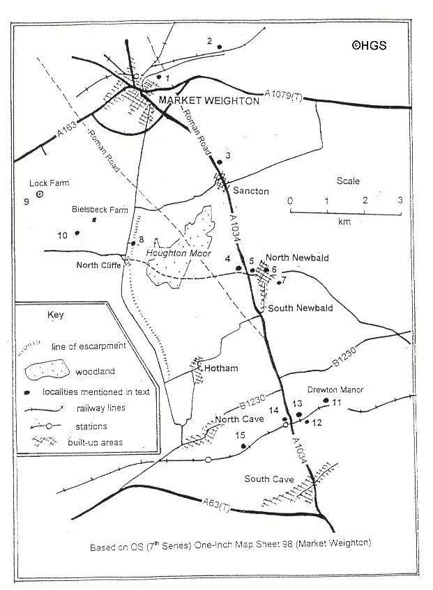
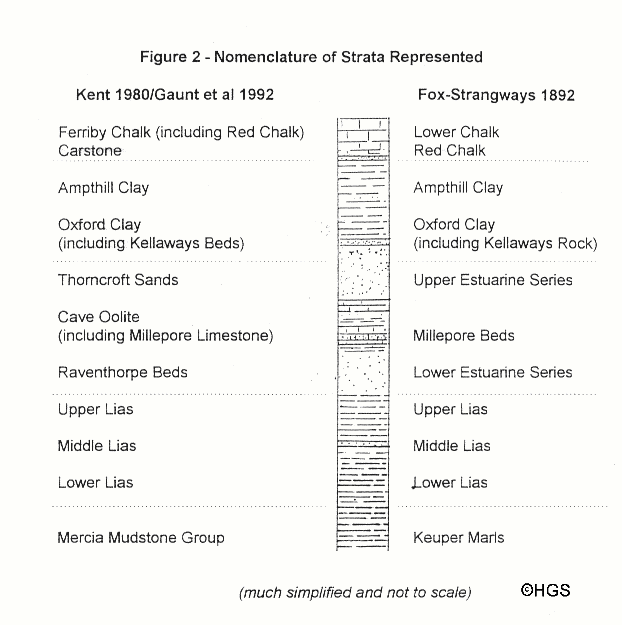
In this contribution I have followed the excursions of Kendall and Wroot using an old (1962) O.S. ‘One-Inch’ map (Market Weighton - Sheet 98) and have attempted to locate the sites they describe as accurately as possible. These sites, fifteen in total, are shown in Figure 1. Their findings from each site are presented, together with, in italicised text in parentheses, an attempted interpretation wherever relevant using modern terminology. Figure 2 includes a stratigraphic column which includes only strata encountered by Kendall and Wroot and which compares a simplified modem nomenclature (based on British Regional Geology. Eastern England from the Tees to The Wash) with that of the Geological Survey of 1880 which they probably used. In addition, I have included fragments of information which may provide the reader with a glimpse of the area's past.
The Sites
Site 1- Kendall and Wroot describe leaving Market Weighton by Houndgate (today's Hungate) and mention that it becomes Spring Road. To the south of this road and up the hill there was a brickyard sited on Lower Lias clays.
Between Sites 1 and 2, the road is described as first climbing a hill, the top of which is the Lower Lias escarpment and where the Roman road crosses Spring Road. It then passes through a deep valley "trenching the escarpment". This was interpreted as a glacial (?Devensian) drainage channel and referred to as the Market Weighton Gap. The high banks bordering the road exposed beds of Red Chalk.
Site 2- Kendall and Wroot describe the next part of their excursion as passing "by the waterworks" and crossing "over the railway to the rifle-butts". They describe the section well known to members of the society as "Lower Grey Chalk" and Red Chalk (lowest beds of the Ferriby Chalk Formation) overlying "the Carr Stone of Norfolk and Lincolnshire" (Carstone) and Lower Lias. Their interpretation of this Cretaceous-Lower
Lias contact is that this site is at ". . . the very heart of the Market Weighton anticline . .". Fossils identified at the site and collected from the Red Chalk included Belemnites minimus (Neohibolites minimus Miller) and Terebratula biplicata (Biplicatoria spp commonly collectively referred to as Moutonithyris dutempleana d'Orbigny)). This site is now a SSSI owned by the Yorkshire Wildlife Trust and has been more recently described by Horne and Dutton (1999) Access is available through either the Y.W.T. or the Secretary of Hull Geological Society.
Site 3- lies to the "north side of Sancton church" where a deposit containing glacial erratics was observed above "a fine section of extremely white sands of the Lower Estuarine series" (this is probably a marine sandstone equivalent of the Raventhorpe Beds, the lower part of the Lincolnshire Limestone)
Site 4- is at a "broad outcrop" of the Millepore Limestone (lower part of the Cave Oolite containing Haploecia straminea (Phillips)) where extensive quarrying had formerly been practised but no exposure was visible even in Kendall and Wroot's day. Whitham (1984) has described a nearby RIGS site section at Sands Top Quarry (SE 907364).
Site 5- is described as being 50 yards (46 metres) from the cross roads (A1034) towards North Newbald. To the south of the "lane" there was "a pit in a bed of sand above the Millepore Limestone" (lower part of Cave Oolite). This site was also described as an important archaeological locality, a Saxon cemetery from which many objects including vases, skeletons and a comb had been excavated. In publications of the Hull Museum these items had apparently been listed as "from Sancton". (interested readers may consult Hull Museum Publications No.3 p.10; 11, 3; and especially 66 and 67).
Site 6- is described as being on the left of the road "just after entering the village of North Newbald". It showed an extensive pit in reddish sand containing good ammonites in the top part of the section "at the north end of the pit". The section was interpreted as Kellaways Rock. ( There appears to be some uncertainty in this interpretation - certainly in my mind - the Regional Guide of 1980, p.52, suggests that the Kellaways Beds may have overlapped Onto Cave Oolite befween Sancton and South Cave but the Memoir for Hull and Brigg of 1992 p.138 states categorically that between North Newbald and Market Weighton "the Chalk lies directly on the Cave Oolite. Could Kendall and Wroot's sand be an arenaceous unit of the Cave Oolite? Unfortunately no identification of the ammonites found there was provided.)
Mike Horne informs me that various small pits have been dug into the Kellaways Sands and Kellaways Rock in this same area over the years and subsequently backfilled. Further information can be found in Whitham (1984).
Site 7- Kendall and Wroot name this locality "Beck Sees" after strong springs which issue here. Although the name does not appear on my edition of the O.S. map, it may be known to local residents. They describe the site as being on wet ground which, together with the springs, give rise to the stream which flows through the village. They correlate this occurrence of wet ground with an outcrop of the Oxford Clay (The Regional Guide of 1980, p.64, mentions North Newbald specifically as the place where a thin attenuated Oxford Clay disappears beneath the sub-Cretaceous unconformity Mike Horne assures me that it is still boggy ground with springs.)
Site 8- . is given as a quarter of a mile north of North Cliffe church, along a private road leading to a farm house. The section described is in "a considerable cutting" which exposed beds of Lower Lias containing scarce ammonites, "but small oysters have been found which have moulded their shells to the ammonite shell ...." . They continue to report that Judd had found such examples "and explained them in his notable Survey Memoir on the Geology of Rutland' but claim that this cutting provided "no better place in the kingdom" for their collection. The authors explain that the cutting was largely made to extract "argillaceous shales" for the improvement of sandy soils to the west. (Mike Horne has informed me that there may have been recent activity in this area. He thinks that gravel and Lias have been extracted but no details are currently available.)
In one day, Kendall and Wroot walked from Market Weighton to North Cave visiting, recording and collecting from Sites 1 to 8, via Hotham. They were probably quite tired by the time they arrived at North Cave because in their book they recommend that "a weary tramp homeward" to Market Weighton could be avoided by ordering in advance "a conveyance ...... from the Londesborough Arms, Market Weighton" which would also "carry the fossil-bags, which should be heavy".
Site 9- Lock House is the site of a borehole drilled in search of coal by a German company "a few years before the war" (presumably the First World War 1914-18). The theory behind the search was that the Market Weighton anticline should have "brought the Carboniferous series into workable reach of the surface " Kendall and Wroot report that drilling stopped after 3100 feet (945 metres) had been penetrated including 971 feet (296 metres) of Permian rocks. (I assume that the remaining thickness of 649 metres was of superficial deposits and Triassic rocks).
Site 10- is a large pond in a field 300 yards (274 metes) south west of Beilsbeck Farm (Kendall and Wroot refer to the farm as Bielsbeck Whether or not this is human error or a genuine change in spelling is unknown). It occupies "the famous excavations" funded by the British Association for the Advancement of Science from 1905 onwards and with which a former secretary of the Hull Geological Society, J.W Stather, was involved (see articles in The Naturalist (1908) 42-45 and in Transactions of the Hull Geolological Society (1908) 6, 103-109)). The excavations produced finds of Pleistocene (?Ipswichian) mammals including lion, straight-tusked elephant, mammoth, two species of rhinoceros, brown bear, wolf, bison, red deer and horse. The deposit "lies in a hollow in the Keuper Marls" which were extracted to strengthen the local sandy soils and control drifting.
Site 11- less than one mile east of South Cave station, "From Hull, Cannon Street stat. 14 m.", Kendall and Wroot report that springs issue from the base of the Red Chalk where it "rests on Ampthill or Oxford Clay" and throw out "an enormous volume of water". These springs they refer to as Drewton Springs.
Site 12- is in a railway cutting on the site of the present SSSI at South Cave Station Quarry where "dark reddish brown and nearly white sands and sandstones" were exposed These included a hard band of brown sandstone which the authors attribute to the Kellaways Rock as it contains many specimens of "the typical oyster Gryphaea bilobata". Clay was visible in the eastern approach to the cutting and, though attributed
to the Oxford Clay, the authors believed that at least a part of the sequence was an argillaceous unit of the "Corallian". (This is possibly a reference again to Ampthill Clay which has been proved by BGS to continue over the Market Weighton structure as far as the Acklam area before passing laterally into the Corallian facies).
Site 13- . The authors describe this as "a large new sandpit" providing a clear face of 25 feet (7.6 metres) "showing every bed". The top of the section was occupied by Kellaways Rock containing Gryphaea sp Beneath this unit the beds (undoubtedly Kellaways Sand) contain calcareous "doggers" (the South Cave Borehole at SE 9366 3230 proved several bands of carbonate.cemented sandstone within the Kellaways Sand) and which the authors considered to be the "best collecting material in Yorkshire for the Kellaways fossils" including "exquisite specimens" of many species of ammonite, "nests" of Rhynchonella socialis (Rhynchonelloidella socialis (phillips)) and Belemnites oweni (Cylindroteuthis sp.).
Between sites 13 and 14, Kendall and Wroot record that "whitish sands are now being worked for glass-making". They attribute these beds tentatively to the Upper Estuarine Series (?Kellaways Sands or Thorncroft Sands Member of the Glentham Formation).
Site 14- this is the station yard of South Cave station where "until recently" there was "a great cliff-like section" exposing fissile, oolitic limestone containing many specimens of Cricopora straminia (Haploecia straminea (Phillips). The authors continue to describe a complex melange of "Millepore Beds, ......... Estuarine sands, chalky Glacial gravel ....." the whole overlain by "overthrust masses of Millepore Bed" and mention that "in the opinion of Mr. J.W Stather" (Proceedings of the Yorkshire Geological Society 1922 ,19, 399) the disturbances can be attributed to "the action of floating ice drifting in an ice-dammed lake in the Ice Age". (The Hull and Brigg Memoir refers to Stather's work, page 115, in relation to a similar pre.Devensian, deposit recorded at Eastfield Quarry - SE 915 324 (also known as Everfhorpe Quarry, a SSSl) . some 150 metres to the south. The conclusion is that this entire hilltop is a giant rafted erratic!)
Site 15- is in another railway cutting where a hard band of calcareous sandstone was observed containing Middle Lias fossils. The authors conclude that because of influence of the Market Weighton structure, this section "affords evidence of a Upper Lias and a Middle Lias only 9 feet (2.7 metres) thick".
On leaving the railway line at the bridge near Everthorpe, the authors noted the large numbers of Gryphaea arcuata (a characteristic Lower Lias 'oyster’) in the fields.
Summary and Acknowledgments
Producing this article has necessitated some research into Jurassic stratigraphy: I had almost forgotten how complicated it can be. Beds thin and thicken, rapidly change in lithology and thickness laterally, not to mention name, so that I was often juggling with four books at a time trying to identify what Kendall and Wroot had seen. Now I know why I spend my time on the Chalk, it's a much less complicated life!
Thanks are expressed to Mike Horne who read through an early manuscript and offered extra information, particularly on the status of some of the sites described, and supplied recent references by members of the Society. His wife, Anne, also read the manuscript and enjoyed it: my thanks to her too for this encouragement.
Further Reading
Gaunt, G D., Fletcher, T.J. and Wood, C.J. 1992. Geology of the country around Kingston upon Hull and Brigg. HMSO for Geological Survey Of Great Britain. 71-101.
Horne, M. and Dutton C. 1999. Rifle Butts Quarry SSSI Humberside Geologist 12, 37.39.
Kent, P.E. 1980 British Regional Geology (Eastern England from the Tees to TheWash) HMSO.
Whitham, F. 1984 The geology of South Newbald Quarry. Humberside Geologist.4, 4-5
Whitham, F. Evening Field Meeting at North Newbald Quarry. Humberside Geologist.4, 14-16
P.N.HILDRETH , Kimberley, Bigby Road, BRIGG, North Lincolnshire.DN20 8BU
(c) Hull Geological Society 1999 + 2001
copyright Hull Geological Society 2020