
Humberside Geologist no 16
Beneath our feet in Welton, Melton and Wauldby:
an introduction to the geology
by Terry Rockett
The
Jurassic Period.
Some 150 million years ago, during the Jurassic Period, the land that underlies this area was at the bottom of a deep sea, the surface of which was some 100 metres higher than present sea level. This sea was between 30°N and 40°N - the same latitude as the coast of North Africa today. Living in this ancient sea were ammonites, belemnites, corals, bivalves, ichthyosaurs, plesiosaurs and many other life forms. Life on the land included cycads, ferns, conifers, insects (including wasps), early birds and mammals, and a number of large reptiles, including dinosaurs. In other parts of the world major events were happening. Africa and North America started to separate initiating the Atlantic Ocean and the mountain building that would produce the Rockies and the Andes.
Locally,
in the late Jurassic, sediments brought to the sea by rivers sank to the sea bed
and built up into a layer of clay some 50m thick. In 1958 15m of these clays
were exposed in the lower Melton Bottoms quarry. At least fourteen different
species of fossils have been found in these clays, including ammonites and
oysters.
The
Cretaceous Period.
The
Jurassic Period was followed by the Cretaceous Period (creta is Latin for chalk). Many of the early rocks of this period do
not exist in this area.
By some
80 million years ago plate tectonics moved this area to about 40°N - a
modern-day Mediterranean latitude. A warm, clear sea up to 600m deep existed. It
teemed with life such as ichthyosaurs, plesiosaurs, ammonites, belemnites,
gastropods, sea urchins and sponges. However the most abundant life forms were
microscopic planktonic algae which, when they died, left a calcium carbonate
skeleton called a coccolith. Millions of these rained down to the sea floor
forming a thick ooze, later to ' dry out ' and become chalk. Up to 90% of chalk
is made up of tiny calcite crystals from these coccoliths. (Similar algae today
live in some clear tropical waters at depths between 50 - 200m.) Flints are
found in some of the Chalk, made of silica derived from sponges, diatoms and
other sources.
On land
there was a rapid development and spread of flowering plants. Trees such as
planes, sycamore, oak, walnut and willow grew along with ferns and conifers.
There was specialisation of reptiles on land, in the sea and in the air. Mammals
reached the size of cats and lived on plants, insects and other creatures. The
first snakes appeared and vast numbers of different insects, including bees,
evolved. Elsewhere the Atlantic continued to widen as South America and South
Africa separated.
In
Melton Bottom Quarry the earliest Cretaceous rock is called Carstone. This thin
layer is made up of pebbles and sand. It is relatively poor in fossils.
Lying on
the Carstone is an unusual layer of Red Chalk about 2m thick. It is very
fossiliferous and has yielded at least 25 different fossil species. The red
colouring is due to traces of iron.
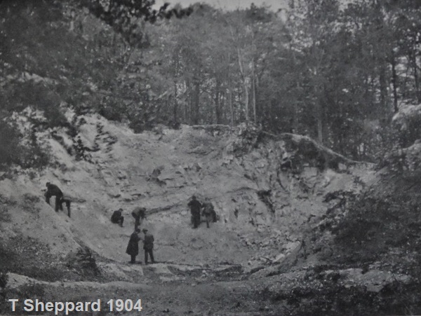
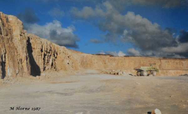
Above this are layers of the more usual 'white' chalk, over 25m thick in the main quarry. In Thomas Sheppard's book ' Geological Rambles in the East Riding of Yorkshire ' (published in 1904) there is a photograph of Melton Bottoms Chalk Pit showing it to be about 8m high and 15m wide.
In
recent years the working face of the quarry has been up to 800m wide - quite a
contrast!
Within
the Chalk is a distinct layer named the 'Black Band'. Fossils are fairly
abundant below the Black Band, virtually absent within the Black Band and new
fossil types develop above it. The Black Band marks a period during which the
extinction of many life forms occurred. This is still being studied by
geologists, but initial indications are that this was caused by an influx of
oxygen-depleted waters spreading over the sea bed, completely changing the
environment and wiping out the existing life, which could not cope with the new
conditions. The Black Band or an equivalent signature can be found throughout
the world in Cretaceous rocks of the same age as the Melton Quarry.
At the
end of the Cretaceous occurred another extinction - a major world-wide one which
resulted in the end of many life forms, most notably the non-avian dinosaurs.
The blamed culprit is a meteorite which hit the Earth near the Yucatan
Peninsula, in the Caribbean. Other factors also probably played a part.
The
Quaternary Period
The time
we live in is called the Quaternary Period by geologists. It started about 2
million years ago. It is often referred to as the Pleistocene Epoch, except for
the last 10,000 years which are referred to as the Holocene Epoch.
At the
start of the Quaternary Period Britain had reached its present geographical
position. The Earth started a period of intense cold - the Pleistocene “Ice
Age”. Ice sheets spread from the poles and, at their peak, covered 30% of the
land surface (compared with 10% today).This was not a period of unrelieved
Arctic conditions - there were numerous short, warm periods (interglacials and
interstadials) when temperatures were as warm as, or warmer than, the present.
The ice spread during the cold periods and regressed when it was warm. At some
time in Britain all the land north of a line from the Scilly Isles to the mouth
of the Thames has been covered by ice.
Some
60,000 to 70,000 years ago there was a small ice sheet in Scotland. At this time
the local coastline ran from approximately Hessle Railway Station through
Harland Way, Cottingham, through Driffield and ended at Sewerby on Flamborough
Head. Ice moved from Scotland, the
Pennines and the Northumberland and Durham coasts. This met with ice which had
crossed the exposed North Sea basin from Scandinavia (global sea level was 120m
lower than today). As they move ice
sheets erode the land and carry the material with them - this is called 'till'.
They also bulldoze frozen material along their front. The ice reached the old
East Yorkshire coastline and moved westwards into the Humber Gap as far as Long
Plantation on the eastern boundary of Welton Parish some 20,000 years ago.
At this
time the climate changed once again and started to warm up. The ice started to
melt and left a bulldozed ridge of material (a terminal moraine) stretching
across the Humber from Red Cliff to South Ferriby and Horkstow in Lincolnshire.
As the area to the east was still covered by ice sheet, melt waters had to flow
westwards beyond the moraine. A vast lake, known to geologists as Lake Humber,
was created which flooded the land as far as the Vale of York and the Trent and
Ancholme Valleys. The eastern section of the M62 crosses the bed of this ancient
lake.
By about
14,000 to 15,000 years ago the ice had retreated far enough for the lake to
drain eastwards through the ridge of moraine and flow towards the North Sea,
creating the present course of the River Humber. As the ice melted it left
behind many millions of tonnes of material it had eroded and carried - Till or
“Boulder Clay”. The deposition of some of this formed the Plain of Holderness.
These tills are subject to rapid erosion - at least 1.6Km of coastline has been
lost since Roman times. The beaches along the coast and Humber are covered with
a range of rocks and fossils carried there from other areas by the ice that are
now being washed out of the tills.
Welton Dale
A major
landscape feature of the parish is Welton Dale - a dry valley. There are many
similar dry valleys along the western edge of the Wolds. Chalk is a porous rock
so why did water not sink into the chalk as it does today? The answer is that
these valleys formed in a periglacial phase when the chalk was frozen to depth
and was impermeable. Surface flow of melted ice and snow cut the valleys. There
are some glacial meltwater channels in the eastern Wolds.
Conclusion
The ice
from the “Ice Age” still exists in Norway, Iceland, Greenland, etc., the “Ice
Age” probably ended in this area about 14,000 years ago. Though the generally
accepted date for the start of the present interglacial is 10,000 years ago. As
yet there is no single explanation for the onset of Ice Ages and the ice could
return.
There is
a lot of evidence about the past to be seen by the observant viewer. It is
possible to find fossils and rocks on the beach between Brickyard Lane and Red
Cliff. If you feel so inclined, have a walk around the Parish along some of the
footpaths and see if you can find some evidence of this area's ancient past.
Safety note - no one should enter a working or worked out quarry without permission and supervision - they are fraught with danger.
If you enjoyed reading the article please consider joining the Society or sending a donation.
copyright Hull Geological Society 2020