
TRANSACTIONS
OF THE
HULL
GEOLOGICAL
SOCIETY
SECTIONS EXPOSED IN A BORING AT HESSLE, E. YORKS.
By J. W. STATHER, F.G.S.
Towards
the end of 1922 the then North-Eastern Railway Company put down a boring for
water at their pumping station at Hessle, on the north Humber shore. This
reached a depth of 181 feet and as the core was practically continuous, 18
ins. in diameter, and was laid out on the floor piece by piece as taken out,
an exceptional opportunity was obtained of investigating the beds.
The water level varied from 18 to21 feet from the
surface, and yielded close upon 20 000 gallons per hour, but unfortunately,
owing to its proximity to the Humber, was too saline to be of any practical
use, and much of the boring had to be plugged with cement.
The following details are supplied by Messrs. Isler and
Co., who carried out the work:-
…………………………………………………………...Thickness……….. Depth.
……………………………………………………………...Feet. ……………Feet.
Hard Chalk
..................................................................... 45……………..…. 45
Chalk and flint
...................................................................1
……………..… 46
Hard chalk with Inoceramus sp .... …………………...103½ …………….149 ½
Red chalk with some grey chalky streaks.
A few small, well-polished quartz grains in matrix ........11…………….... 160 ½
Fine brown incoherent sand ………………………….. . 2 ……………….162½
Bluish-black clay containing a few molluscan borings
in-filled with a gritty glauconitic clay
............................. 8½ ……………...181
The core really commenced at a depth of 17 feet from
the surface at this point, which is 10 feet above Ordnance Datum, as it
commenced at the bottom of a well made to that depth.
An examination of the core shows that the beds are in
very hard white chalk with occasionally small finger flints, which entirely
disappear at a depth of 60 feet, the only definite flint band being at a
depth of 45 feet from the surface.
Fossils, as is the case elsewhere in the immediate
neighbourhood, were exceedingly scarce, and beyond a few fragments of
Inoceramus, nothing occurred to assist in identifying the precise zones.
At a depth of 70 feet from the surface, traces of the
" black band " or Bel. plena zone were unmistakable. This zone is
important, separating as it does the Middle from the Lower Chalk. Below this
pink bands and the familiar " grey bed " described by Hill, were also
unmistakable, and still further down, as shown in the accompanying section,
were beds of the red chalk proper, containing Belemnites minimus and
fragments of Inoceramus. At
the base of this Red Chalk occurred in bed of
“fine brown incoherent sand, 2 feet thick." This we did not see
in place, though a small heap shown to us by the men, kept near the boring,
indicated a sharp, coarse green grain.
Immediately beneath this, and at a depth of 162½ feet,
a bluish-black clay was penetrated, in general appearance greatly resembling
the Oolitic clays occurring at Melton and other places. This contained a
number of fossils, upon which Mr. Pringle gives the following report :-- "
Grammatodon sp., Protocardia morincia? de Lor., Thracia
sp. and ammonite fragments, but these shells were not sufficiently
well-preserved to indicate the zonal position of the clay. The
Grammatodon, which we have not identified specifically, has some
resemblance to Blake's Grammatodon longipunctata, which came from the
Lower Kimmeridge of Market Rasen: Although the ammonites are too fragmentary
to be named, they strongly suggest that the clay belongs to the Lower
Kimmeridge Clay."
On plotting this section to scale with the sections
given in the plate accompanying Hill's paper on the Lower Beds of the Upper
Cretaceous Series in Yorkshire and Lincolnshire (Q.].G.S.,
vol. xliv, 1888) several important features call for comment.
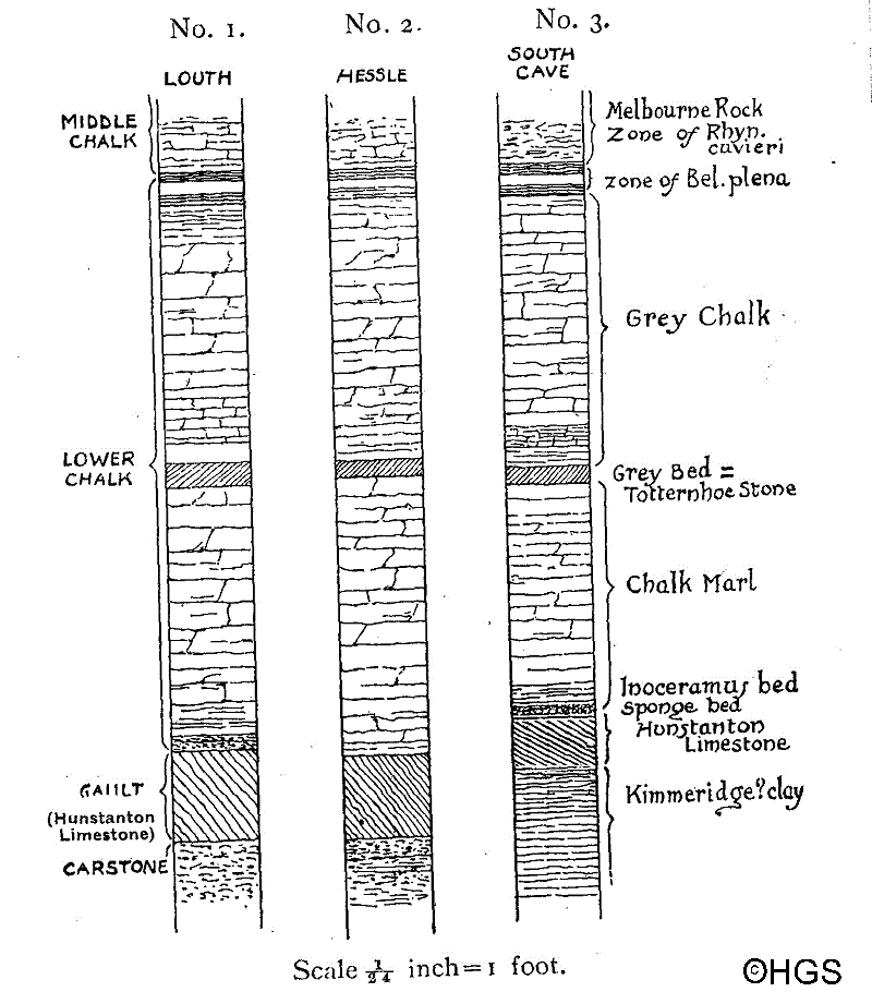
In the first place, the extraordinary regularity in the
occurrence of the various beds as proved by sections in South Lincolnshire
near Welton, Central Lincolnshire near Louth, the present section at Hessle,
and the
The Hessle boring shown in No.2 of the accompanying
section, which is drawn to the same scale as the others, is of interest as
showing the depth of the Red Chalk on the north Humber shore, when it
occupies precisely the relative position that it does at South Cave, further
north, and also at Louth and at several other places over a large area in
Lincolnshire. In thickness also it is fairly constant. Below it, at Hessle,
the bed of sand is clearly the Carstone, which does not occur in the South
Cave cuttings, though possibly represented by a few polished phosphatic
pebbles at the base of the Red Chalk.
It is remarkable that while the Red Chalk occurs at a
depth of 160 feet at Hessle, on the south shore of the Humber, at South
Ferriby, it occurs on the beach, and can be examined at low water. At this
point, however, the Lower, or Grey Chalk on the beach is, now and then, at a
high angle, occasionally almost perpendicular, no doubt largely due to a
squeezing-out process at the foot of the Lincolnshire Wolds, where, as on
the northern escarpment of the Yorkshire Wolds, similar phenomena are
observable, due to the great weight of the chalk resting on wet Oolitic
clays.
In preparing these notes I have had the advantage of
assistance from Messrs. J. Pringle and T. Sheppard.
[Note -This article has been scanned in from original printed format and then put through an OCR program by Mike Horne. The process may have introduced some new spelling errors to the texts. Some original misspellings have been corrected.]

Copyright Hull Geological Society 2020